Onde Viver Bem

World · France

Rennes

indicative score regional figure

6.89 / 10

Technical notes for this page

Updated November 10, 2026. Indicative score. Weights: entertainment 11.73% (destinations and venues within 50 km); bars 3.73%; safety 15% with a penalty; water at country level; land price per m² = official source (ITBI, Terracap, registries, valuations) or listings with a caveat · coverage 100%

Rennes has an indicative score of 6.89/10 in the World ranking of Onde Viver Bem, updated November 10, 2026. The strongest published variables are Beach / mountains (10.00), Clean air (9.02) and Parks (8.65); the weakest are Sun (2.15), Mild climate (3.56) and Safety (4.41). The scores are indicative. Cost of living and the land price per m² are not part of the score.
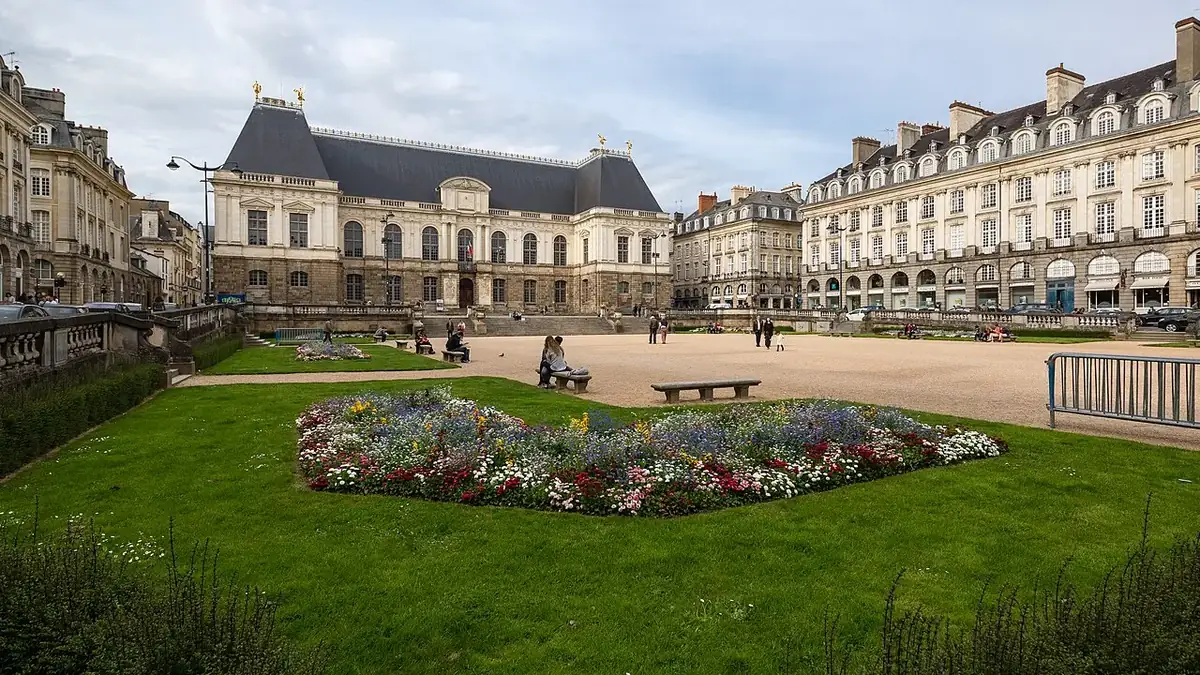
Rennes: view of the city
Rennes. Photo: Édouard Hue (User:EdouardHue), CC BY-SA 3.0, Wikimedia Commons.
safety: homicide for the department (SSMSI) and undetermined-intent deaths for the region (Eurostat NUTS2)

Land price per m²

US$ 885/m² (EUR 791) · P25–P75 US$ 171–US$ 1,443 · n=37

DVF (DGFiP) — median of building-land sales, 2023–2025

Collected November 10, 2026 · exchange rate EUR 0.89342 per US$ (Frankfurter API (ECB reference rates), 2026-11-09)

Score breakdown

Each criterion's score, its weight in the total and the raw figure, linked to its source.

Safety · score 4.41 · weight 15.00% · sources: homicidios_100k_local (4.64) · homicidios_100k_policia (1.78) · obitos_indeterminados_100k (2.86) · roubo_razao_cidade_pais (2.71) · sensacao_seguranca_noite_pct (68.8)
raw: 4.64 per 100k pop. · 40% violent deaths (log 30→0, 0.5→10 per 100k) + 30% city robbery ÷ country average (log 5×→0, 0.5×→10) + 30% share who feel safe at night (lin 30%→0, 95%→10); any part without data: weights renormalized
Composite safety: violent deaths 4.6 per 100k → 4.6 (weight 40%) · robbery 2.71× the country average (commune 35238, 2025) → 2.7 (weight 30%) · 68.8% feel safe walking alone at night (Rennes (greater city) FR016C, 2023) → 6.0 (weight 30%).
Beach / mountains · score 10.00 · weight 11.59% · sources: km_ate_praia_osm (5.0) · km_ate_relevo_montanhoso (>150) · osm_cachoeiras_50km (4.0) · osm_areas_protegidas_50km (44.0) · osm_trilhas_rota_50km (401.0) · osm_mirantes_50km (98.0)
raw: 5.0 km · beach: distance log 5 km→10, 150 km→0; mountains: richness of nature leisure (mean of the top 3 of 4 counts, 50 km) × access (1 up to 15 km → 0 at 150 km, log), 0 with no relief; score = min(10, max(beach, mountains) + 0.3·min)
Water · score 8.32 · weight 9.94% · sources: wb_estresse_hidrico_pais (21.385) · wb_agua_gerida_segura_pais (99.713)
raw: 21.385 % withdrawal / available resources · average: stress log 100%→0, 10%→10; safe water lin 50%→0, 100%→10
Parks · score 8.65 · weight 9.94% · sources: osm_parques_2km (73.0) · osm_parques_municipio (152.0)
raw: 73.0 count of OSM objects · 50% log1p(count within 2 km), 60→10 + 50% log1p(per 10k pop.), 15→10
Sun · score 2.15 · weight 9.94% · sources: radiacao_solar_global (1236.5)
raw: 1236.5 kWh/m²/year · lin 1000→0, 2100→10 kWh/m²/year
Restaurants · score 7.75 · weight 9.11% · sources: osm_restaurantes_2km (303.0) · osm_restaurantes_municipio (380.0) · overture_restaurantes_2km (535.0) · overture_restaurantes_municipio (697.0)
raw: Average of two mapping sources, OpenStreetMap and Overture Maps (Overture count ÷ K, K = median Overture/OSM ratio across the 39 cities: 2.57 within 2 km, 3.41 in the municipality); each source: 50% log1p(count within 2 km), 1000→10 + 50% log1p(per 10k pop.), 30→10. Brazil: 50% of that score + 50% log1p(CNPJ per 10k pop. ÷ K), 30→10
Entertainment · score 7.41 · weight 11.73% · sources: osm_destinos_entretenimento_50km (23.0) · osm_arenas_grandes_50km (11.0)
raw: 34.0 count of OSM objects (destinations + venues, 50 km) · log1p(destinations + stadiums/music venues), 120→10; 50 km radius
A1ed, radius 50 km: 23.0 destinations (theme_park/zoo/aquarium/water_park) + 11.0 stadiums/music venues (stadium, music_venue, concert_hall). Left out: events_venue, sports_centre, theatre, amusement_ride, amusement_arcade. OpenStreetMap via ohsome.
Bars · score 7.31 · weight 3.73% · sources: osm_bares_2km (146.0) · osm_bares_municipio (170.0) · overture_bares_2km (168.0) · overture_bares_municipio (206.0)
raw: Average of two mapping sources, OpenStreetMap and Overture Maps (Overture count ÷ K, K = median Overture/OSM ratio across the 39 cities: 2.48 within 2 km, 3.20 in the municipality); each source: 50% log1p(count within 2 km), 500→10 + 50% log1p(per 10k pop.), 10→10. Brazil: 50% of that score + 50% log1p(CNPJ per 10k pop. ÷ K), 10→10
Mild climate · score 3.56 · weight 4.97% · sources: dias_conforto_termico (117.6)
raw: 117.6 days/year · lin 0→0, 330→10 days/year
Health · score 7.93 · weight 4.97% · sources: wb_expectativa_vida (82.98) · osm_hospitais_10km (16.0)
raw: 82.98 years · average: life expectancy lin 70→0, 85→10; Brazil: beds/10k pop. lin 0→0, 50→10; World: OSM hospitals within 10 km log1p 50→10
Clean air · score 9.02 · weight 4.14% · sources: pm25_media_anual (7.93)
raw: 7.93 µg/m³ · lin 35→0, 5→10 µg/m³ (WHO=5)
Airport · score 7.00 · weight 2.48% · sources: osm_aeroportos_iata_50km (1.0)
raw: 1.0 count of OSM objects · 0→0, 1→7, ≥2→10
Culture · score 8.09 · weight 2.48% · sources: osm_cultura_5km (57.0)
raw: 57.0 count of OSM objects · log1p(count), 150→10

The city

Rennes is a French commune in the administrative region of Brittany, in the Ille-et-Vilaine department. Rennes had 209,860 inhabitants within the city limits in 2012, making it the largest city in Brittany, the second in north-western France, the third on the French Atlantic arc and, finally, the eleventh most populous commune in France. Its urban area, with 690,467 inhabitants in 2012, is the tenth largest in the country.

English rendering of the Portuguese Wikipedia summary linked below. Source: wikipedia_pt. Wikipedia revision 73111236 (2026-10-03T03:48:28Z).

Taxation

DMTO (droits de mutation à titre onéreux, transfer duties): Ille-et-Vilaine: departmental rate 5.00% (4.50% for a first home, art. 1594 D) + communal rate 1.20% + frais d'assiette of 2.37% of the departmental rate ≈ 6.32% in total. Base: declared price. DGFiP table in force on May 1, 2026 (higher rate under the 2025 finance law, art. 116 II); new property falls under VAT DGFiP — impots.gouv.fr (tabela DMTO 01/05/2026)

Taxe foncière sur les propriétés bâties (TFPB, property tax on buildings): 47.39% (commune 45.66% + Rennes Métropole 1.73%) on the cadastral base (50% of the cadastral rental value). Base: cadastral rental value × 50%. Rates voted in 2025 (DGFiP, July 22, 2025). Excludes syndicates, special taxes, GEMAPI and the TEOM (waste collection). DGCL / DGFiP — Taux de fiscalité directe locale votés en 2025 (communes e EPCI)

Frequently asked questions

What is the Onde Viver Bem score for Rennes?

Rennes has an indicative score of 6.89/10 in the World ranking, updated November 10, 2026. Cost of living is not part of the score.

What are the strengths and weaknesses of the score for Rennes?

The strongest published variables are Beach / mountains (10.00), Clean air (9.02) and Parks (8.65); the weakest are Sun (2.15), Mild climate (3.56) and Safety (4.41).

Does cost of living or the land price per m² enter the score?

No. Cost of living and the land price per m² appear on the page but are not part of the score. See the methodology.

How is the score calculated?

It is an indicative 0–10 quality-of-life index, with 13 variables and published weights. Safety has a 15% weight and, when local data exist, a lethal-violence penalty may cap the total. The full method is on the methodology page.

Are any figures on this page estimates?

This page has no value marked as an estimate. Each metric cites its source.

Cities with a nearby score

Informational content and indicative scores. This is not advice on investing, immigration, buying property or choosing a career. Every metric cites its source; cost of living is not part of the score.