Best places for your bunker
Updated 18 Nov 2026
Update and correction (18 Nov 2026): 6 regions were added, and the seismic rule changed (fault sub-score capped at 8; no mapped fault counts as 8). Of the 23 regions published on 17 Nov, 22 lost 0.01 to 0.11 points. Positions also changed because of the new regions.
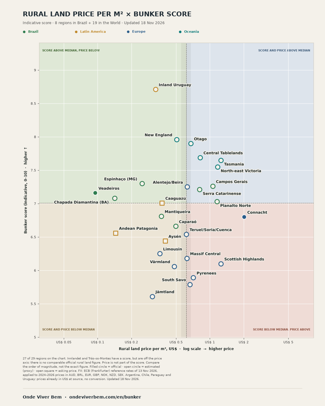
Indicative comparison of 29 rural regions (8 in Brazil, 21 in the World), with scores dated 18 Nov 2026. The score covers water, climate, sunshine, natural hazards and land rules. The chart and table show rural land price indicators per m², of different types, for 27 of the 29 regions; Innlandet and Trás-os-Montes are off the price axis, because there is no comparable official figure. Price is not part of the score.
The scores are indicative. Do not use this list on its own to buy a property or build a shelter.
- Brazil
- Espinhaço (MG), score 7.30, but the sensitivity ranges of the 8 regions in group A overlap or chain; the order of the lead is not robust to the scenarios tested: Espinhaço (MG) can rank from 1 to 3, and Campos Gerais 7.26 also reach first place in the simulations.
- World
- Inland Uruguay, score 8.7 (range 8.4–8.9).
- Land price on the chart
- from US$ 0.0951/m² (Veadeiros) to US$ 2.01/m² (Connacht). Innlandet and Trás-os-Montes are off the price axis.
Rural land price per m² × bunker score
27 of 29 regions on the chart · 18 Nov 2026
BrazilLatin AmericaEuropeOceaniaFilled circle: official. Open circle: estimate. Open square: asking price.

Share chart
- 1 Inland Uruguay
- 2 New England
- 3 Otago
- 4 Central Tablelands
- 5 Tasmania
- 6 North-east Victoria
- 7 Espinhaço (MG)
- 8 Campos Gerais
- 9 Alentejo/Beira
- 10 Serra Catarinense
- 11 Veadeiros
- 12 Chapada Diamantina (BA)
- 13 Planalto Norte
- 14 Caaguazú
- 15 Mantiqueira
- 16 Connacht
- 17 Caparaó
- 18 Andean Patagonia
- 19 Teruel/Soria/Cuenca
- 20 Aysén
- 21 Limousin
- 22 Massif Central
- 23 Scottish Highlands
- 24 Värmland
- 25 Pyrenees
- 26 South Savo
- 27 Jämtland
Tap, hover or focus a point to see the region name, the score and the land price. The link in the tip jumps to that region in the list.
How to read the chart
With 27 points, the price median is Teruel/Soria/Cuenca itself; the Massif Central (+1.0%), Alentejo/Beira, South Savo and Otago also fall inside the band. The score median (7.01) is Caaguazú's, right next to Planalto Norte (7.03). The quadrant of these regions is an effect of the cut. On a phone, the numbers match the table and the list under the chart (a reading key, not a combined Brazil+World rank). Medians use the plotted points only. Price is not part of the score. The values are heterogeneous rural price indicators: official bare-land value by market region, official assessed value (barème), sales statistics that may include improvements, and asking prices; the source list gives each point's type. FX of 13 Nov 2026. Tap or hover a point to see the name, or use the keyboard.
Trás-os-Montes: Rural land price per m²: no comparable official figure; only NUTS2 Norte exists, dominated by the coast. Innlandet: Bare-land price per m²: no reliable official figure.
Full list of land-price sources
- Inland Uruguay: DIEA/MGAP 2025: mean of recorded farmland sales in Tacuarembó, Rivera and Durazno (USD/ha) (2025) — derived from official data; type: farmland price statistic (official or market).
- New England: Estimated, regional proxy including improvements: A$ 7,444/ha (Bendigo 2026 report, 2025 median for New England & North West; the reference region includes areas outside the box; the direction of the bias is unknown; known municipal values: Armidale A$8,112/ha and Uralla A$4,776/ha) (2025) — estimated (regional proxy, includes improvements); type: median total sale price (may include improvements).
- Otago: Estimated: NZ$ 12,191/ha (Bayleys Nov 2025 citing the REINZ Otago grazing median, 12 months to Sep 2025) (2025) — estimated (proxy); type: farmland price statistic (official or market).
- Central Tablelands: Separate category, farmland WITH improvements (not bare land): about A$12k/ha, 2025 medians of rural property sales in 7 LGAs (Bendigo 2026), weighted by sales; compare the order of magnitude only. (2025) — estimated (municipal proxy, includes improvements); type: farmland including improvements (rural property sales).
- Tasmania: Estimated, regional proxy including improvements: A$ 18,424/ha (Bendigo 2026 report, 2025 state median; includes peri-urban Hobart) (2025) — estimated (regional proxy, includes improvements); type: median total sale price (may include improvements).
- North-east Victoria: Estimated, regional proxy including improvements: A$ 17,216/ha (Bendigo 2026 report, 2025 median for Ovens Murray; includes the dairy valleys) (2025) — estimated (regional proxy, includes improvements); type: median total sale price (may include improvements).
- Espinhaço (MG): Estimated: INCRA Atlas 2025 (2024 reference), general VTN of market regions weighted by the area of the 35 municipalities in the box, R$ 14,105.83/ha (min–max R$ 8,022.50–14,105.83) (2024 (Atlas 2025)) — estimated (weighted mean of official market regions); type: official bare-land value by market region (VTN, INCRA).
- Campos Gerais: Estimated: INCRA Atlas 2025 (2024 reference), general VTN of market regions weighted by the area of the 30 municipalities in the box, R$ 59,947.38/ha (min–max R$ 59,947.38–73,251.43) (2024 (Atlas 2025)) — estimated (weighted mean of official market regions); type: official bare-land value by market region (VTN, INCRA).
- Alentejo/Beira: Estimated: €5,678/ha (Eurostat/INE, Alentejo 2024 arable, provisional). No 2025 series; Beira has no separate figure. (2024) — estimated (proxy); type: farmland price statistic (official or market).
- Serra Catarinense: INCRA Atlas 2025: mean of general VTN SC-1007 Planalto Serrano and RS-1102 Campos de Cima (2024 (Atlas 2025)) — derived from official data; type: official bare-land value by market region (VTN, INCRA).
- Veadeiros: INCRA Atlas 2025: general VTN GO-2807 (the market region that contains Chapada dos Veadeiros) (2024 (Atlas 2025)) — official; type: official bare-land value by market region (VTN, INCRA).
- Chapada Diamantina (BA): INCRA Atlas 2025: general VTN BA-505 Feira de Santana (market region wider than the Chapada; estimated) (2024 (Atlas 2025)) — estimated (proxy); type: official bare-land value by market region (VTN, INCRA).
- Planalto Norte: Estimated: INCRA Atlas 2025 (2024 reference), general VTN of market regions weighted by the area of the 48 municipalities in the box, R$ 65,394.30/ha (min–max R$ 55,668.16–65,394.30) (2024 (Atlas 2025)) — estimated (weighted mean of official market regions); type: official bare-land value by market region (VTN, INCRA).
- Caaguazú: Estimated: US$ 3,750/ha (median of two 2025/26 Caaguazú listings: Carayaó US$ 4,500 and Cecilio Báez US$ 3,000/ha) (2025–2026) — asking price, n=2; type: asking price in listings.
- Mantiqueira: INCRA Atlas 2025: mean of general VTN MG-607 Pouso Alegre and SP-801 East (SP-801 includes the coast; estimated) (2024 (Atlas 2025)) — estimated (proxy); type: official bare-land value by market region (VTN, INCRA).
- Connacht: CSO 2025: West region median (Galway, Mayo, Roscommon), €7,374/acre (2025) — official; type: farmland price statistic (official or market).
- Caparaó: Estimated: INCRA Atlas 2025 (2024 reference), general VTN of market regions weighted by the area of the 59 municipalities in the box, R$ 28,083.33/ha (min–max R$ 28,083.33–33,094.95) (2024 (Atlas 2025)) — estimated (weighted mean of official market regions); type: official bare-land value by market region (VTN, INCRA).
- Andean Patagonia: Estimated: US$ 1,450/ha (mean of the mid-points of May 2026 asking ranges: Neuquén US$ 500–3,000 and Río Negro US$ 300–2,000/ha) (2026) — asking price; type: asking price in listings.
- Teruel/Soria/Cuenca: MAPA 2025 (provisional): mean of the Aragón, Castile and León and Castilla-La Mancha averages (no provincial figure; estimated) (2025) — estimated (proxy); type: farmland price statistic (official or market).
- Aysén: Estimated: US$ 4,000/ha (mid-range for Aysén in Land of Patagonia’s 2026 price guide; asking ranges, not official transactions) (2026) — asking price; type: asking price in listings.
- Limousin: Estimated: official 2025 barème (Légifrance, 10 Aug 2026) for the 17 agricultural regions in the box, area-weighted, €3,239.11/ha (min–max 2,998.57–3,571.76) (2025) — estimated (official barème, area-weighted); type: official assessed value of vacant farmland (barème).
- Massif Central: Official: 2025 farmland barème (Légifrance, 10 Aug 2026), simple mean of the 4 départements, €5,631.25/ha (2025) — derived from official data; type: official assessed value of vacant farmland (barème).
- Scottish Highlands: Estimated: £9,497/ha (SLC 2024 mean, Highlands and Islands). No official regional £/ha for 2025. (2024) — estimated (proxy); type: farmland price statistic (official or market).
- Värmland: Estimated (NUTS2 area, not the region alone): SEK 48,300/ha of arable land in 2025 (Jordbruksverket JO1002L1; 52,900 in 2024) (2025) — estimated (proxy); type: farmland price statistic (official or market).
- Pyrenees: Estimated: 2025 barème (Légifrance, 10 Aug 2026), 15 agricultural regions in the box weighted by area, €6,445.83/ha (range 6,057.14–7,203.83) (2025) — estimated (official barème, area-weighted); type: official assessed value of vacant farmland (barème).
- South Savo: Luke 2025: Northern and Eastern Finland arable land (€6,013/ha; includes South Savo; estimated) (2025) — estimated (proxy); type: farmland price statistic (official or market).
- Jämtland: Estimated (NUTS2 area, not the region alone): SEK 30,800/ha of arable land in 2025 (Jordbruksverket JO1002L1; 30,300 in 2024) (2025) — estimated (proxy); type: farmland price statistic (official or market).
Brazil
Group A, positions 1 to 8: chained ranges — each region's position range in the simulations (p5–p95) overlaps a neighbour's, although not every pair overlaps. Read them as a group, not as a firm order.
| 7 Southern Espinhaço (Diamantina–Serro, MG) Brazil | 7.3 | 6.8 a 7.6 | US$ 0.249/m² estimated (weighted mean of official market regions), 2024 (Atlas 2025)Estimated: INCRA Atlas 2025 (2024 reference), general VTN of market regions weighted by the area of the 35 municipalities in the box, R$ 14,105.83/ha (min–max R$ 8,022.50–14,105.83) |
| 8 Campos Gerais (Paraná) Brazil | 7.3 | 6.5 a 7.6 | US$ 1.06/m² estimated (weighted mean of official market regions), 2024 (Atlas 2025)Estimated: INCRA Atlas 2025 (2024 reference), general VTN of market regions weighted by the area of the 30 municipalities in the box, R$ 59,947.38/ha (min–max R$ 59,947.38–73,251.43) |
| 10 Serra Catarinense and Campos de Cima da Serra Brazil | 7.2 | 6.7 a 7.5 | US$ 0.808/m² derived from official data, 2024 (Atlas 2025)INCRA Atlas 2025: mean of general VTN SC-1007 Planalto Serrano and RS-1102 Campos de Cima |
| 11 Chapada dos Veadeiros Brazil | 7.2 | 6.7 a 7.5 | US$ 0.0951/m² official, 2024 (Atlas 2025)INCRA Atlas 2025: general VTN GO-2807 (the market region that contains Chapada dos Veadeiros) |
| 12 Chapada Diamantina (BA) Brazil | 7.1 | 6.6 a 7.3 | US$ 0.142/m² estimated (proxy), 2024 (Atlas 2025)INCRA Atlas 2025: general VTN BA-505 Feira de Santana (market region wider than the Chapada; estimated) |
| 13 Northern Santa Catarina Plateau and southern Paraná Brazil | 7.0 | 6.5 a 7.3 | US$ 1.15/m² estimated (weighted mean of official market regions), 2024 (Atlas 2025)Estimated: INCRA Atlas 2025 (2024 reference), general VTN of market regions weighted by the area of the 48 municipalities in the box, R$ 65,394.30/ha (min–max R$ 55,668.16–65,394.30) |
| 15 Serra da Mantiqueira Brazil | 6.8 | 6.2 a 7.2 | US$ 0.370/m² estimated (proxy), 2024 (Atlas 2025)INCRA Atlas 2025: mean of general VTN MG-607 Pouso Alegre and SP-801 East (SP-801 includes the coast; estimated) |
| 17 Caparaó and the Espírito Santo highlands Brazil | 6.7 | 6.0 a 6.9 | US$ 0.496/m² estimated (weighted mean of official market regions), 2024 (Atlas 2025)Estimated: INCRA Atlas 2025 (2024 reference), general VTN of market regions weighted by the area of the 59 municipalities in the box, R$ 28,083.33/ha (min–max R$ 28,083.33–33,094.95) |
Leading candidates · sensitivity ranges overlap or chain, the order of the lead is not robust · position in the simulations 1–3
Southern Espinhaço (Diamantina–Serro, MG) Brazil
7.3 sensitivity 6.8–7.6
Rural land: US$ 0.249/m² (estimated (weighted mean of official market regions), 2024 (Atlas 2025)).
Each IBGE municipality (2024 boundaries) touching the box gets the general VTN (level 0) of its market region in INCRA's 2025 Land Market Atlas (published 31 Dec 2025, 2024 market reference). Weight = municipal area inside the box. MG-613 Teófilo Otoni R$ 8,022.50 (weight 55.1%, 14 mun.); MG-610 Belo Horizonte R$ 28,346.83 (weight 26.4%, 11 mun.); MG-612 Governador Valadares R$ 15,252.27 (weight 12.7%, 7 mun.); MG-601 Montes Claros R$ 4,695.27 (weight 5.8%, 3 mun.). Weighted mean: R$ 14,105.83/ha. A market-region VTN is not a sale price inside the box. Estimated. Sensitivity range: R$ 8,022.50 to R$ 14,105.83/ha (US$ 0.14 to US$ 0.25/m²), from the weighted value to market region MG-613 alone. Market region MG-613 Teófilo Otoni covers 55% of the box but is very wide (it reaches the Mucuri valley); market region MG-610 Belo Horizonte (26% of the area) pulls the weighted value up.
Warning: Lead not firm (#1–#3 in the simulations), alongside Campos Gerais (Paraná) (score 7.30).
- Surface water and growing climate8.5
- Measured natural hazards and climate7.8
- Stability and geopolitical exposure5.3
- Solar energy8.3
- Isolation and density8.3
- Institutions and access to land5.3
Strongest: surface water and growing climate, isolation and density. Weakest: stability and geopolitical exposure, institutions and access to land.
Nearby on the city ranking: Belo Horizonte, Montes Claros.
Facts, land rules and method
PV output 1,556 kWh/kWp a year, worst month 113; rain 1,153 mm a year and 5 dry months (1991–2020); 1 days a year at 35 °C or more and 365 growing days (1991–2020, corrected against 2 INMET stations, estimated; only 2 stations, at very different elevations, so the correction is uncertain; uncorrected model: 7 days at 35 °C or more); 16.5 people/km²; 422 thousand within 100 km; 0 M5+ earthquakes within 100 km since 1973 (USGS); no active fault slipping 1 mm/yr or more mapped within 150 km (GEM coverage is partial; this is not evidence of safety).
Purchase by a Brazilian individual: A Brazilian individual buys rural land with no nationality rule; the general rules apply (registry, georeferencing/CCIR, CAR and, within the 150 km border strip, specific rules). (source: Lei 5.709/1971 (aplica-se a estrangeiros); Lei 6.634/1979 (faixa de fronteira), checked 16/11/2026)
Other choices: arithmetic mean 7.4; best 25% of cells 7.3; without the nuclear-status item 6.9; without frost in hazards 7.3; unmapped fault scored 7.5 7.3; pessimistic seismic case 7.3. Heat threshold 30/60/90 days: 7.3/7.3/7.3; without the station correction 7.2/7.2/7.3; elevation-weighted correction 7.3.
Score = median of 6 of 6 eligible 50 km cells; largest contiguous block 6; 88% of the area is not excluded by the databases consulted (this does not show that land is available or buildable).
Leading candidates · sensitivity ranges overlap or chain, the order of the lead is not robust · position in the simulations 1–7
Campos Gerais (Paraná) Brazil
7.3 sensitivity 6.5–7.6
Rural land: US$ 1.06/m² (estimated (weighted mean of official market regions), 2024 (Atlas 2025)).
Each IBGE municipality (2024 boundaries) touching the box gets the general VTN (level 0) of its market region in INCRA's 2025 Land Market Atlas (published 31 Dec 2025, 2024 market reference). Weight = municipal area inside the box. PR-902 Campos Gerais R$ 73,251.43 (weight 69.6%, 18 mun.); PR-903 Centro Sul R$ 42,771.96 (weight 16.1%, 5 mun.); PR-901 Litoral / Metropolitano R$ 14,313.23 (weight 14.2%, 7 mun.). Weighted mean: R$ 59,947.38/ha (previously R$ 73,251.43/ha). A market-region VTN is not a sale price inside the box. Estimated. Sensitivity range: R$ 59,947.38 to R$ 73,251.43/ha (US$ 1.06 to US$ 1.29/m²), from the weighted value to market region PR-902 alone. About 30% of the box lies in other land markets (PR-903 and PR-901), outside the Campos Gerais proper.
Warning: Lead not firm (#1–#7 in the simulations), alongside Southern Espinhaço (Diamantina–Serro, MG) (score 7.26).
- Surface water and growing climate9.6
- Measured natural hazards and climate8.4
- Stability and geopolitical exposure5.3
- Solar energy7.5
- Isolation and density5.7
- Institutions and access to land5.3
Strongest: surface water and growing climate, measured natural hazards and climate. Weakest: stability and geopolitical exposure, institutions and access to land.
Nearby on the city ranking: Curitiba, Londrina, Joinville.
Facts, land rules and method
PV output 1,455 kWh/kWp a year, worst month 104; rain 1,558 mm a year and 0 dry months (1991–2020); 0 days a year at 35 °C or more and 363 growing days (1991–2020, corrected against 6 INMET stations, estimated); 34.8 people/km²; 1,501 thousand within 100 km; 0 M5+ earthquakes within 100 km since 1973 (USGS); no active fault slipping 1 mm/yr or more mapped within 150 km (GEM coverage is partial; this is not evidence of safety).
Purchase by a Brazilian individual: A Brazilian individual buys rural land with no nationality rule; the general rules apply (registry, georeferencing/CCIR, CAR and, within the 150 km border strip, specific rules). (source: Lei 5.709/1971 (aplica-se a estrangeiros); Lei 6.634/1979 (faixa de fronteira), checked 16/11/2026)
Other choices: arithmetic mean 7.5; best 25% of cells 7.5; without the nuclear-status item 6.8; without frost in hazards 7.3; unmapped fault scored 7.5 7.2; pessimistic seismic case 7.3. Heat threshold 30/60/90 days: 7.3/7.3/7.3; without the station correction 7.3/7.3/7.3; elevation-weighted correction 7.3.
Score = median of 9 of 9 eligible 50 km cells; largest contiguous block 9; 98% of the area is not excluded by the databases consulted (this does not show that land is available or buildable).
Group A · positions not conclusively separated, no order within the group · position in the simulations 2–5
Serra Catarinense and Campos de Cima da Serra Brazil
7.2 sensitivity 6.7–7.5
Rural land: US$ 0.808/m² (derived from official data, 2024 (Atlas 2025)).
INCRA Land Market Atlas 2025. Unweighted simple mean of the general VTN (level 0) of market regions SC-1007 Planalto Serrano and RS-1102 Campos de Cima.
- Surface water and growing climate9.5
- Measured natural hazards and climate8.0
- Stability and geopolitical exposure5.3
- Solar energy7.2
- Isolation and density6.7
- Institutions and access to land5.3
Strongest: surface water and growing climate, measured natural hazards and climate. Weakest: stability and geopolitical exposure, institutions and access to land.
Nearby on the city ranking: Gramado, Florianópolis, Caxias do Sul, Porto Alegre. Articles: Florianópolis.
Facts, land rules and method
PV output 1,468 kWh/kWp a year, worst month 94; rain 1,671 mm a year and 0 dry months (1991–2020); 0 days a year at 35 °C or more and 356 growing days (1991–2020, corrected against 15 INMET stations, estimated); 18.9 people/km²; 913 thousand within 100 km; 0 M5+ earthquakes within 100 km since 1973 (USGS); no active fault slipping 1 mm/yr or more mapped within 150 km (GEM coverage is partial; this is not evidence of safety).
Purchase by a Brazilian individual: A Brazilian individual buys rural land with no nationality rule; the general rules apply (registry, georeferencing/CCIR, CAR and, within the 150 km border strip, specific rules). (source: Lei 5.709/1971 (aplica-se a estrangeiros); Lei 6.634/1979 (faixa de fronteira), checked 16/11/2026)
Other choices: arithmetic mean 7.4; best 25% of cells 7.3; without the nuclear-status item 6.8; without frost in hazards 7.2; unmapped fault scored 7.5 7.2; pessimistic seismic case 7.2. Heat threshold 30/60/90 days: 7.2/7.2/7.2; without the station correction 7.2/7.2/7.2; elevation-weighted correction 7.2.
Score = median of 13 of 13 eligible 50 km cells; largest contiguous block 13; 97% of the area is not excluded by the databases consulted (this does not show that land is available or buildable).
Group A · positions not conclusively separated, no order within the group · position in the simulations 2–6
Chapada dos Veadeiros Brazil
7.2 sensitivity 6.7–7.5
Rural land: US$ 0.0951/m² (official, 2024 (Atlas 2025)).
- Surface water and growing climate8.3
- Measured natural hazards and climate6.5
- Stability and geopolitical exposure5.3
- Solar energy9.1
- Isolation and density9.8
- Institutions and access to land5.3
Strongest: isolation and density, solar energy. Weakest: stability and geopolitical exposure, institutions and access to land.
Nearby on the city ranking: Brasília, Goiânia. Articles: Brasília.
Facts, land rules and method
PV output 1,708 kWh/kWp a year, worst month 117; rain 1,247 mm a year and 5 dry months (1991–2020); 31 days a year at 35 °C or more and 365 growing days (1991–2020, corrected against 2 INMET stations, estimated; only 2 stations, at very different elevations, so the correction is uncertain; uncorrected model: 65 days at 35 °C or more); 2.0 people/km²; 150 thousand within 100 km; 0 M5+ earthquakes within 100 km since 1973 (USGS); no active fault slipping 1 mm/yr or more mapped within 150 km (GEM coverage is partial; this is not evidence of safety).
Purchase by a Brazilian individual: A Brazilian individual buys rural land with no nationality rule; the general rules apply (registry, georeferencing/CCIR, CAR and, within the 150 km border strip, specific rules). (source: Lei 5.709/1971 (aplica-se a estrangeiros); Lei 6.634/1979 (faixa de fronteira), checked 16/11/2026)
Other choices: arithmetic mean 7.3; best 25% of cells 7.4; without the nuclear-status item 6.8; without frost in hazards 7.2; unmapped fault scored 7.5 7.1; pessimistic seismic case 7.2. Heat threshold 30/60/90 days: 7.0/7.2/7.2; without the station correction 7.0/7.0/7.1; elevation-weighted correction 7.1.
Score = median of 12 of 12 eligible 50 km cells; largest contiguous block 12; 90% of the area is not excluded by the databases consulted (this does not show that land is available or buildable).
Group A · positions not conclusively separated, no order within the group · position in the simulations 3–6
Chapada Diamantina (BA) Brazil
7.1 sensitivity 6.6–7.3
Rural land: US$ 0.142/m² (estimated (proxy), 2024 (Atlas 2025)).
- Surface water and growing climate7.6
- Measured natural hazards and climate7.8
- Stability and geopolitical exposure5.3
- Solar energy8.3
- Isolation and density8.2
- Institutions and access to land5.3
Strongest: solar energy, isolation and density. Weakest: stability and geopolitical exposure, institutions and access to land.
Nearby on the city ranking: Salvador.
Facts, land rules and method
PV output 1,570 kWh/kWp a year, worst month 112; rain 715 mm a year and 5 dry months (1991–2020); 1 days a year at 35 °C or more and 365 growing days (1991–2020, corrected against 4 INMET stations, estimated); 16.1 people/km²; 453 thousand within 100 km; 0 M5+ earthquakes within 100 km since 1973 (USGS); no active fault slipping 1 mm/yr or more mapped within 150 km (GEM coverage is partial; this is not evidence of safety).
Purchase by a Brazilian individual: A Brazilian individual buys rural land with no nationality rule; the general rules apply (registry, georeferencing/CCIR, CAR and, within the 150 km border strip, specific rules). (source: Lei 5.709/1971 (aplica-se a estrangeiros); Lei 6.634/1979 (faixa de fronteira), checked 16/11/2026)
Other choices: arithmetic mean 7.2; best 25% of cells 7.2; without the nuclear-status item 6.7; without frost in hazards 7.1; unmapped fault scored 7.5 7.1; pessimistic seismic case 7.1. Heat threshold 30/60/90 days: 7.1/7.1/7.1; without the station correction 7.0/7.0/7.0; elevation-weighted correction 7.1.
Score = median of 18 of 18 eligible 50 km cells; largest contiguous block 18; 96% of the area is not excluded by the databases consulted (this does not show that land is available or buildable).
Group A · positions not conclusively separated, no order within the group · position in the simulations 3–7
Northern Santa Catarina Plateau and southern Paraná Brazil
7.0 sensitivity 6.5–7.3
Rural land: US$ 1.15/m² (estimated (weighted mean of official market regions), 2024 (Atlas 2025)).
Each IBGE municipality (2024 boundaries) touching the box gets the general VTN (level 0) of its market region in INCRA's 2025 Land Market Atlas (published 31 Dec 2025, 2024 market reference). Weight = municipal area inside the box. SC-1016 Canoinhas R$ 55,668.16 (weight 58.0%, 15 mun.); PR-902 Campos Gerais R$ 73,251.43 (weight 17.0%, 12 mun.); SC-1005 Joaçaba R$ 83,138.03 (weight 8.5%, 4 mun.); PR-903 Centro Sul R$ 42,771.96 (weight 7.6%, 5 mun.); SC-1014 Blumenau R$ 69,785.30 (weight 5.2%, 5 mun.); SC-1015 Joinville R$ 223,345.81 (weight 2.8%, 3 mun.); SC-1006 Curitibanos R$ 86,416.21 (weight 0.4%, 1 mun.); SC-1013 Rio do Sul R$ 54,926.71 (weight 0.3%, 2 mun.); PR-901 Litoral / Metropolitano R$ 14,313.23 (weight 0.2%, 1 mun.). Weighted mean: R$ 65,394.30/ha. A market-region VTN is not a sale price inside the box. Estimated. Sensitivity range: R$ 55,668.16 to R$ 65,394.30/ha (US$ 0.98 to US$ 1.15/m²), from the weighted value to market region SC-1016 alone. About 42% of the box lies outside market region SC-1016 Canoinhas, in pricier (Campos Gerais PR, Joaçaba, Joinville) and cheaper (Centro Sul PR) land markets.
Warning: Low spatial coverage: only 3 eligible 50 km cells (about 7,500 km², the required minimum), a small part of the box; in practice the score behaves almost like a single cell's, and the 2 × 2 block resampling barely varies.
- Surface water and growing climate9.6
- Measured natural hazards and climate7.8
- Stability and geopolitical exposure5.3
- Solar energy6.4
- Isolation and density6.0
- Institutions and access to land5.3
Strongest: surface water and growing climate, measured natural hazards and climate. Weakest: stability and geopolitical exposure, institutions and access to land.
Nearby on the city ranking: Joinville, Curitiba, Blumenau.
Facts, land rules and method
PV output 1,344 kWh/kWp a year, worst month 87; rain 1,600 mm a year and 0 dry months (1991–2020); 0 days a year at 35 °C or more and 358 growing days (1991–2020, corrected against 4 INMET stations, estimated); 39.5 people/km²; 976 thousand within 100 km; 0 M5+ earthquakes within 100 km since 1973 (USGS); no active fault slipping 1 mm/yr or more mapped within 150 km (GEM coverage is partial; this is not evidence of safety).
Purchase by a Brazilian individual: A Brazilian individual buys rural land with no nationality rule; the general rules apply (registry, georeferencing/CCIR, CAR and, within the 150 km border strip, specific rules). (source: Lei 5.709/1971 (aplica-se a estrangeiros); Lei 6.634/1979 (faixa de fronteira), checked 16/11/2026)
Other choices: arithmetic mean 7.2; best 25% of cells 7.2; without the nuclear-status item 6.6; without frost in hazards 7.0; unmapped fault scored 7.5 7.0; pessimistic seismic case 7.0. Heat threshold 30/60/90 days: 7.0/7.0/7.0; without the station correction 7.0/7.0/7.0; elevation-weighted correction 7.0.
Score = median of 3 of 3 eligible 50 km cells; largest contiguous block 3; 99% of the area is not excluded by the databases consulted (this does not show that land is available or buildable).
Group A · positions not conclusively separated, no order within the group · position in the simulations 6–8
Serra da Mantiqueira Brazil
6.8 sensitivity 6.2–7.2
Rural land: US$ 0.370/m² (estimated (proxy), 2024 (Atlas 2025)).
- Surface water and growing climate9.2
- Measured natural hazards and climate7.8
- Stability and geopolitical exposure5.2
- Solar energy8.4
- Isolation and density3.6
- Institutions and access to land5.3
Strongest: surface water and growing climate, solar energy. Weakest: stability and geopolitical exposure, isolation and density.
Nearby on the city ranking: Campos do Jordão, Petrópolis, São José dos Campos.
Facts, land rules and method
PV output 1,552 kWh/kWp a year, worst month 117; rain 1,463 mm a year and 3 dry months (1991–2020); 0 days a year at 35 °C or more and 365 growing days (1991–2020, corrected against 17 INMET stations, estimated); 47.9 people/km²; 2,873 thousand within 100 km; 0 M5+ earthquakes within 100 km since 1973 (USGS); no active fault slipping 1 mm/yr or more mapped within 150 km (GEM coverage is partial; this is not evidence of safety).
Purchase by a Brazilian individual: A Brazilian individual buys rural land with no nationality rule; the general rules apply (registry, georeferencing/CCIR, CAR and, within the 150 km border strip, specific rules). (source: Lei 5.709/1971 (aplica-se a estrangeiros); Lei 6.634/1979 (faixa de fronteira), checked 16/11/2026)
Other choices: arithmetic mean 7.1; best 25% of cells 7.1; without the nuclear-status item 6.3; without frost in hazards 6.8; unmapped fault scored 7.5 6.8; pessimistic seismic case 6.8. Heat threshold 30/60/90 days: 6.8/6.8/6.8; without the station correction 6.7/6.8/6.8; elevation-weighted correction 6.8.
Score = median of 15 of 15 eligible 50 km cells; largest contiguous block 15; 97% of the area is not excluded by the databases consulted (this does not show that land is available or buildable).
Group A · positions not conclusively separated, no order within the group · position in the simulations 7–8
Caparaó and the Espírito Santo highlands Brazil
6.7 sensitivity 6.0–6.9
Rural land: US$ 0.496/m² (estimated (weighted mean of official market regions), 2024 (Atlas 2025)).
Each IBGE municipality (2024 boundaries) touching the box gets the general VTN (level 0) of its market region in INCRA's 2025 Land Market Atlas (published 31 Dec 2025, 2024 market reference). Weight = municipal area inside the box. MG-609 Juiz de Fora R$ 21,312.81 (weight 34.7%, 25 mun.); ES-2008 Serrano R$ 31,522.00 (weight 24.9%, 9 mun.); ES-2011 Sul R$ 24,728.00 (weight 15.3%, 9 mun.); ES-2010 Sudoeste II R$ 29,172.00 (weight 13.2%, 5 mun.); ES-2009 Sudoeste I R$ 50,373.00 (weight 9.1%, 4 mun.); ES-2007 Centro – Oeste R$ 21,739.00 (weight 1.9%, 2 mun.); MG-611 Ipatinga R$ 23,688.34 (weight 0.4%, 3 mun.); ES-2012 Litoral Sul R$ 26,567.00 (weight 0.3%, 1 mun.); MG-612 Governador Valadares R$ 15,252.27 (weight 0.2%, 1 mun.). Weighted mean: R$ 28,083.33/ha (previously R$ 33,094.95/ha). A market-region VTN is not a sale price inside the box. Estimated. Sensitivity range: R$ 28,083.33 to R$ 33,094.95/ha (US$ 0.496 to US$ 0.584/m²), from the weighted value to the simple mean of market regions used before.
- Surface water and growing climate9.1
- Measured natural hazards and climate7.2
- Stability and geopolitical exposure5.3
- Solar energy7.4
- Isolation and density4.1
- Institutions and access to land5.3
Strongest: surface water and growing climate, solar energy. Weakest: institutions and access to land, isolation and density.
Nearby on the city ranking: Vitória, Juiz de Fora, Belo Horizonte.
Facts, land rules and method
PV output 1,434 kWh/kWp a year, worst month 106; rain 1,237 mm a year and 3 dry months (1991–2020); 1 days a year at 35 °C or more and 365 growing days (1991–2020, corrected against 8 INMET stations, estimated); 51.6 people/km²; 2,275 thousand within 100 km; 0 M5+ earthquakes within 100 km since 1973 (USGS); no active fault slipping 1 mm/yr or more mapped within 150 km (GEM coverage is partial; this is not evidence of safety).
Purchase by a Brazilian individual: A Brazilian individual buys rural land with no nationality rule; the general rules apply (registry, georeferencing/CCIR, CAR and, within the 150 km border strip, specific rules). (source: Lei 5.709/1971 (aplica-se a estrangeiros); Lei 6.634/1979 (faixa de fronteira), checked 16/11/2026)
Other choices: arithmetic mean 6.9; best 25% of cells 6.8; without the nuclear-status item 6.3; without frost in hazards 6.7; unmapped fault scored 7.5 6.6; pessimistic seismic case 6.7. Heat threshold 30/60/90 days: 6.7/6.7/6.7; without the station correction 6.7/6.7/6.7; elevation-weighted correction 6.7.
Score = median of 4 of 4 eligible 50 km cells; largest contiguous block 4; 96% of the area is not excluded by the databases consulted (this does not show that land is available or buildable).
World
Group A: Inland Uruguay (Tacuarembó, Rivera, Durazno) (position 1) stands alone; its position range in the simulations (p5–p95) is 1 and does not touch the next region's. Group B, positions 2 to 21: chained ranges — each region's position range in the simulations (p5–p95) overlaps a neighbour's, although not every pair overlaps. Read them as a group, not as a firm order.
| 1 Inland Uruguay (Tacuarembó, Rivera, Durazno) Uruguay | 8.7 | 8.4 a 8.9 | US$ 0.328/m² derived from official data, 2025DIEA/MGAP 2025: mean of recorded farmland sales in Tacuarembó, Rivera and Durazno (USD/ha) |
| 2 New England (New South Wales) Australia | 8.0 | 7.6 a 8.2 | US$ 0.505/m² estimated (regional proxy, includes improvements), 2025Estimated, regional proxy including improvements: A$ 7,444/ha (Bendigo 2026 report, 2025 median for New England & North West; the reference region includes areas outside the box; the direction of the bias is unknown; known municipal values: Armidale A$8,112/ha and Uralla A$4,776/ha) |
| 3 Otago (inland) New Zealand | 7.9 | 7.5 a 8.2 | US$ 0.674/m² estimated (proxy), 2025Estimated: NZ$ 12,191/ha (Bayleys Nov 2025 citing the REINZ Otago grazing median, 12 months to Sep 2025) |
| 4 Central Tablelands (New South Wales) Australia | 7.7 | 7.3 a 8.0 | US$ 0.819/m² estimated (municipal proxy, includes improvements), 2025Separate category, farmland WITH improvements (not bare land): about A$12k/ha, 2025 medians of rural property sales in 7 LGAs (Bendigo 2026), weighted by sales; compare the order of magnitude only. |
| 5 Tasmania Australia | 7.7 | 7.3 a 8.0 | US$ 1.25/m² estimated (regional proxy, includes improvements), 2025Estimated, regional proxy including improvements: A$ 18,424/ha (Bendigo 2026 report, 2025 state median; includes peri-urban Hobart) |
| 6 North-east Victoria (Ovens Murray and the High Country) Australia | 7.5 | 7.2 a 8.0 | US$ 1.17/m² estimated (regional proxy, includes improvements), 2025Estimated, regional proxy including improvements: A$ 17,216/ha (Bendigo 2026 report, 2025 median for Ovens Murray; includes the dairy valleys) |
| 9 Alentejo and Beira Interior Portugal | 7.2 | 6.9 a 7.6 | US$ 0.628/m² estimated (proxy), 2024Estimated: €5,678/ha (Eurostat/INE, Alentejo 2024 arable, provisional). No 2025 series; Beira has no separate figure. |
| Trás-os-Montes (Bragança and Vila Real) Portugal | 7.1 | 6.7 a 7.4 | Rural land price per m²: no comparable official figure; only NUTS2 Norte exists, dominated by the coast |
| 14 Inland eastern Paraguay (Caaguazú, Guairá) Paraguay | 7.0 | 6.6 a 7.4 | US$ 0.375/m² asking price, n=2, 2025–2026Estimated: US$ 3,750/ha (median of two 2025/26 Caaguazú listings: Carayaó US$ 4,500 and Cecilio Báez US$ 3,000/ha) |
| 16 Connacht and the western Midlands Ireland | 6.8 | 6.2 a 7.2 | US$ 2.01/m² official, 2025CSO 2025: West region median (Galway, Mayo, Roscommon), €7,374/acre |
| 18 Andean Patagonia (Neuquén, Río Negro, Chubut) Argentina | 6.6 | 6.1 a 6.9 | US$ 0.145/m² asking price, 2026Estimated: US$ 1,450/ha (mean of the mid-points of May 2026 asking ranges: Neuquén US$ 500–3,000 and Río Negro US$ 300–2,000/ha) |
| 19 Teruel, Soria and Cuenca Spain | 6.5 | 6.1 a 7.0 | US$ 0.616/m² estimated (proxy), 2025MAPA 2025 (provisional): mean of the Aragón, Castile and León and Castilla-La Mancha averages (no provincial figure; estimated) |
| 20 Aysén Chile | 6.4 | 5.9 a 6.8 | US$ 0.400/m² asking price, 2026Estimated: US$ 4,000/ha (mid-range for Aysén in Land of Patagonia’s 2026 price guide; asking ranges, not official transactions) |
| 21 Limousin (Creuse, Haute-Vienne and northern Corrèze) France | 6.2 | 5.5 a 6.7 | US$ 0.358/m² estimated (official barème, area-weighted), 2025Estimated: official 2025 barème (Légifrance, 10 Aug 2026) for the 17 agricultural regions in the box, area-weighted, €3,239.11/ha (min–max 2,998.57–3,571.76) |
| 22 Massif Central (Cantal, Lozère, Aveyron, Haute-Loire) France | 6.2 | 5.6 a 6.7 | US$ 0.622/m² derived from official data, 2025Official: 2025 farmland barème (Légifrance, 10 Aug 2026), simple mean of the 4 départements, €5,631.25/ha |
| 23 Scottish Highlands United Kingdom | 6.1 | 5.3 a 6.6 | US$ 1.26/m² estimated (proxy), 2024Estimated: £9,497/ha (SLC 2024 mean, Highlands and Islands). No official regional £/ha for 2025. |
| 24 Värmland Sweden | 6.1 | 5.6 a 6.5 | US$ 0.481/m² estimated (proxy), 2025Estimated (NUTS2 area, not the region alone): SEK 48,300/ha of arable land in 2025 (Jordbruksverket JO1002L1; 52,900 in 2024) |
| 25 French Pyrenees (Ariège, Comminges, Bigorre) France | 5.9 | 5.4 a 6.4 | US$ 0.712/m² estimated (official barème, area-weighted), 2025Estimated: 2025 barème (Légifrance, 10 Aug 2026), 15 agricultural regions in the box weighted by area, €6,445.83/ha (range 6,057.14–7,203.83) |
| Innlandet (Gudbrandsdalen and Hedmark) Norway | 5.8 | 5.3 a 6.2 | Bare-land price per m²: no reliable official figure |
| 26 South Savo (Etelä-Savo) Finland | 5.8 | 5.3 a 6.2 | US$ 0.665/m² estimated (proxy), 2025Luke 2025: Northern and Eastern Finland arable land (€6,013/ha; includes South Savo; estimated) |
| 27 Jämtland Sweden | 5.6 | 5.1 a 6.0 | US$ 0.306/m² estimated (proxy), 2025Estimated (NUTS2 area, not the region alone): SEK 30,800/ha of arable land in 2025 (Jordbruksverket JO1002L1; 30,300 in 2024) |
Leader of this list · same position in at least 90% of simulations
Inland Uruguay (Tacuarembó, Rivera, Durazno) Uruguay
8.7 sensitivity 8.4–8.9
Rural land: US$ 0.328/m² (derived from official data, 2025).
DIEA/MGAP 2025. Unweighted simple mean of the official average sale prices of Tacuarembó, Rivera and Durazno.
Warning: Heat and cold here have no station correction. We removed it because the station data that would allow it (GHCN-Daily) are licensed only for non-commercial use outside the US. Without it, the climate model's error may go either way. Estimated.
- Surface water and growing climate9.0
- Measured natural hazards and climate8.3
- Stability and geopolitical exposure9.8
- Solar energy7.7
- Isolation and density9.4
- Institutions and access to land8.1
Strongest: stability and geopolitical exposure, isolation and density. Weakest: institutions and access to land, solar energy.
Nearby on the city ranking: Montevideo.
Facts, land rules and method
PV output 1,573 kWh/kWp a year, worst month 92; rain 1,388 mm a year and 0 dry months (1991–2020); 12 days a year at 35 °C or more and 357 growing days (1991–2020, no station correction, estimated); 2.1 people/km²; 135 thousand within 100 km; 0 M5+ earthquakes within 100 km since 1973 (USGS); no active fault slipping 1 mm/yr or more mapped within 150 km (GEM coverage is partial; this is not evidence of safety).
Purchase by a Brazilian citizen not resident in the country (individual): Foreign individuals buy without nationality restrictions; companies holding rural land need registered (nominative) shares. (source: Ley 18.092 (2007), checked 16/11/2026)
Other choices: arithmetic mean 8.7; best 25% of cells 8.9; without the nuclear-status item 8.7; without frost in hazards 8.7; unmapped fault scored 7.5 8.7; pessimistic seismic case 8.7. Heat threshold 30/60/90 days: 8.7/8.7/8.7.
Score = median of 32 of 32 eligible 50 km cells; largest contiguous block 32; 99% of the area is not excluded by the databases consulted (this does not show that land is available or buildable).
Group B · positions not conclusively separated, no order within the group · position in the simulations 2–3
New England (New South Wales) Australia
8.0 sensitivity 7.6–8.2
Rural land: US$ 0.505/m² (estimated (regional proxy, includes improvements), 2025).
Warning: In the 2019–20 season, 529,069 ha burned in the New England bush fire management committee area, which spans about 1.37 million ha and covers Armidale (4,235 km²), Uralla (3,230 km²) and Walcha (6,267 km²), according to the NSW Rural Fire Service (https://www.rfs.nsw.gov.au/plan-and-prepare/managing-bush-fire-risk/bush-fire-management-committees/new-england). That area covers only part of the box: the box reaches north to latitude −29°, including Glen Innes and Tenterfield, outside the committee area. The fire score counts MODIS detections (satellite thermal anomalies), which do not measure local bushfire hazard or severity. source
Warning: Heat and cold here have no station correction. We removed it because the station data that would allow it (GHCN-Daily) are licensed only for non-commercial use outside the US. Without it, the climate model's error may go either way. Estimated.
- Surface water and growing climate8.5
- Measured natural hazards and climate7.2
- Stability and geopolitical exposure7.1
- Solar energy9.1
- Isolation and density10.0
- Institutions and access to land7.1
Strongest: isolation and density, solar energy. Weakest: stability and geopolitical exposure, institutions and access to land.
Nearby on the city ranking: Brisbane, Sydney. Articles: Brisbane, Sydney.
Facts, land rules and method
PV output 1,708 kWh/kWp a year, worst month 118; rain 785 mm a year and 0 dry months (1991–2020); 4 days a year at 35 °C or more and 347 growing days (1991–2020, no station correction, estimated); 1.2 people/km²; 72 thousand within 100 km; 0 M5+ earthquakes within 100 km since 1973 (USGS); no active fault slipping 1 mm/yr or more mapped within 150 km (GEM coverage is partial; this is not evidence of safety).
Purchase by a Brazilian citizen not resident in the country (individual): Foreign individual: vacant residential land needs prior FIRB/ATO approval and a duty to build; buying established dwellings is banned from 1 Apr 2025 to 31 Mar 2027; agricultural land needs registration and, above the cumulative threshold (A$15 million), approval. (source: Foreign Acquisitions and Takeovers Act 1975; FIRB Guidance Note 6 (Residential land, 2025); guia de terra agrícola, checked 16/11/2026)
Other choices: arithmetic mean 8.0; best 25% of cells 8.2; without the nuclear-status item 8.1; without frost in hazards 8.0; unmapped fault scored 7.5 7.9; pessimistic seismic case 8.0. Heat threshold 30/60/90 days: 7.9/8.0/8.0.
Score = median of 15 of 15 eligible 50 km cells; largest contiguous block 15; 82% of the area is not excluded by the databases consulted (this does not show that land is available or buildable).
Group B · positions not conclusively separated, no order within the group · position in the simulations 2–6
Otago (inland) New Zealand
7.9 sensitivity 7.5–8.2 seismic score: incomplete proxy
Rural land: US$ 0.674/m² (estimated (proxy), 2025).
Warning: The seismic score is an incomplete proxy (proximity to mapped faults and historical seismicity), not a measure of seismic hazard, and here the hazard is probably understated: the score uses mapped active faults (GEM) and the earthquake catalogue, but not New Zealand's probabilistic national model (NZ NSHM 2022), which we could not obtain under a usable licence and format. That model gives Dunedin a peak ground acceleration of 0.26 g with a 10% chance of being exceeded in 50 years (reference site Vs30 = 250 m/s) (GNS Science regional summary, 2022). The Alpine Fault, capable of very large quakes every few centuries, runs west of the region. source
Warning: Heat and cold here have no station correction. We removed it because the station data that would allow it (GHCN-Daily) are licensed only for non-commercial use outside the US. Without it, the climate model's error may go either way. Estimated.
- Surface water and growing climate8.3
- Measured natural hazards and climate7.3
- Stability and geopolitical exposure9.3
- Solar energy6.1
- Isolation and density9.5
- Institutions and access to land7.5
Strongest: isolation and density, stability and geopolitical exposure. Weakest: measured natural hazards and climate, solar energy.
Nearby on the city ranking: Wellington, Auckland.
Facts, land rules and method
PV output 1,370 kWh/kWp a year, worst month 79; rain 889 mm a year and 0 dry months (1991–2020); 0 days a year at 35 °C or more and 275 growing days (1991–2020, no station correction, estimated); 2.6 people/km²; 182 thousand within 100 km; 0 M5+ earthquakes within 100 km since 1973 (USGS); active fault slipping 1 mm/yr or more mapped within 150 km (GEM).
Purchase by a Brazilian citizen not resident in the country (individual): Rural land over 5 ha is 'sensitive land': non-resident foreigners need Overseas Investment Office consent. (source: Overseas Investment Act 2005, checked 16/11/2026)
Excluded by filters: 2 cells with a magnitude 7+ earthquake within 50 km since 1900.
Other choices: arithmetic mean 8.0; best 25% of cells 8.2; without the nuclear-status item 7.9; without frost in hazards 7.9; unmapped fault scored 7.5 7.9; pessimistic seismic case 7.8. Heat threshold 30/60/90 days: 7.9/7.9/7.9.
Score = median of 13 of 15 eligible 50 km cells (excluded: 2 near a fast-slipping fault or with high seismicity; a cell may have more than one reason); largest contiguous block 13; 82% of the area is not excluded by the databases consulted (this does not show that land is available or buildable).
Group B · positions not conclusively separated, no order within the group · position in the simulations 3–6
Central Tablelands (New South Wales) Australia
7.7 sensitivity 7.3–8.0
Rural land: US$ 0.819/m² (estimated (municipal proxy, includes improvements), 2025).
2025 medians by municipality (LGA) from the Bendigo 2026 report (non-official, a bank report) for the 7 tableland LGAs in the box, weighted by number of sales: Bathurst A$11,358/ha (30 sales); Blayney A$14,092/ha (17 sales); Cabonne A$13,290/ha (50 sales); Lithgow A$15,065/ha (39 sales); Mid-Western A$8,492/ha (81 sales); Oberon A$13,658/ha (20 sales); Orange A$28,880/ha (4 sales). Weighted mean A$12,070.00/ha (241 sales). We do not use the Central West regional median (A$6,571/ha, 608 sales) because it includes the western plains (Bogan A$1,299, Warren A$3,336), much cheaper than the tablelands. A mean of medians is not a median; Cabonne and Mid-Western lie only partly in the box. Sensitivity range (LGAs with ≥ 10 sales): A$8,492 to A$15,065/ha. The Bendigo report uses total sale prices, which can include improvements; it is a proxy, not a bare-land price. Estimated.
Warning: Density isolation 9.53 with a median density of 4.24 people/km² is not an error. The sub-score is the median of the 6 cells' sub-scores (8.0; 8.0; 9.05; 10; 10; 10), not the sub-score of the median density; cells under 1 person/km² get 8.0 (distant services) and one cell has 34.9 people/km² (Orange/Bathurst).
Warning: Heat and cold here have no station correction. We removed it because the station data that would allow it (GHCN-Daily) are licensed only for non-commercial use outside the US. Without it, the climate model's error may go either way. Estimated.
- Surface water and growing climate7.8
- Measured natural hazards and climate7.7
- Stability and geopolitical exposure7.1
- Solar energy8.2
- Isolation and density8.7
- Institutions and access to land7.1
Strongest: isolation and density, solar energy. Weakest: stability and geopolitical exposure, institutions and access to land.
Nearby on the city ranking: Sydney, Canberra. Articles: Sydney.
Facts, land rules and method
PV output 1,641 kWh/kWp a year, worst month 97; rain 691 mm a year and 0 dry months (1991–2020); 6 days a year at 35 °C or more and 327 growing days (1991–2020, no station correction, estimated); 4.2 people/km²; 198 thousand within 100 km; 0 M5+ earthquakes within 100 km since 1973 (USGS); no active fault slipping 1 mm/yr or more mapped within 150 km (GEM coverage is partial; this is not evidence of safety).
Purchase by a Brazilian citizen not resident in the country (individual): Foreign individual: vacant residential land needs prior FIRB/ATO approval and a duty to build; buying established dwellings is banned from 1 Apr 2025 to 31 Mar 2027; agricultural land needs registration and, above the cumulative threshold (A$15 million), approval. (source: Foreign Acquisitions and Takeovers Act 1975; FIRB Guidance Note 6 (Residential land, 2025); guia de terra agrícola, checked 16/11/2026)
Other choices: arithmetic mean 7.7; best 25% of cells 7.9; without the nuclear-status item 7.8; without frost in hazards 7.7; unmapped fault scored 7.5 7.7; pessimistic seismic case 7.7. Heat threshold 30/60/90 days: 7.6/7.7/7.7.
Score = median of 6 of 6 eligible 50 km cells; largest contiguous block 6; 91% of the area is not excluded by the databases consulted (this does not show that land is available or buildable).
Group B · positions not conclusively separated, no order within the group · position in the simulations 3–6
Tasmania Australia
7.7 sensitivity 7.3–8.0
Rural land: US$ 1.25/m² (estimated (regional proxy, includes improvements), 2025).
Warning: Heat and cold here have no station correction. We removed it because the station data that would allow it (GHCN-Daily) are licensed only for non-commercial use outside the US. Without it, the climate model's error may go either way. Estimated.
- Surface water and growing climate9.1
- Measured natural hazards and climate7.8
- Stability and geopolitical exposure7.0
- Solar energy6.0
- Isolation and density9.0
- Institutions and access to land7.1
Strongest: surface water and growing climate, isolation and density. Weakest: stability and geopolitical exposure, solar energy.
Nearby on the city ranking: Melbourne, Sydney, Brisbane. Articles: Brisbane.
Facts, land rules and method
PV output 1,356 kWh/kWp a year, worst month 73; rain 1,028 mm a year and 0 dry months (1991–2020); 0 days a year at 35 °C or more and 344 growing days (1991–2020, no station correction, estimated); 0.8 people/km²; 204 thousand within 100 km; 0 M5+ earthquakes within 100 km since 1973 (USGS); no active fault slipping 1 mm/yr or more mapped within 150 km (GEM coverage is partial; this is not evidence of safety).
Purchase by a Brazilian citizen not resident in the country (individual): Foreign individual: vacant residential land needs prior FIRB/ATO approval and a duty to build; buying established dwellings is banned from 1 Apr 2025 to 31 Mar 2027; agricultural land needs registration and, above the cumulative threshold (A$15 million), approval. (source: Foreign Acquisitions and Takeovers Act 1975; FIRB Guidance Note 6 (Residential land, 2025); guia de terra agrícola, checked 16/11/2026)
Excluded by filters: 3 cells with less than 25% of the area outside protected areas and indigenous lands.
Other choices: arithmetic mean 7.8; best 25% of cells 7.9; without the nuclear-status item 7.8; without frost in hazards 7.7; unmapped fault scored 7.5 7.6; pessimistic seismic case 7.7. Heat threshold 30/60/90 days: 7.7/7.7/7.7.
Score = median of 22 of 25 eligible 50 km cells (excluded: 3 in a protected or restricted area; a cell may have more than one reason); largest contiguous block 21; 65% of the area is not excluded by the databases consulted (this does not show that land is available or buildable).
Group B · positions not conclusively separated, no order within the group · position in the simulations 3–7
North-east Victoria (Ovens Murray and the High Country) Australia
7.5 sensitivity 7.2–8.0 seismic score: incomplete proxy
Rural land: US$ 1.17/m² (estimated (regional proxy, includes improvements), 2025).
Warning: The Woods Point earthquake (Mw 5.9, 22 Sep 2021 local time; USGS us7000fd9v) had its epicentre about 21 km south of the box. It enters the catalogue for some cells (two have 5.9 as the largest magnitude within 75 km), but it does not move the median of the cells, which sets the score. Australia's national probabilistic model (NSHA18, Geoscience Australia) is not included. source
Warning: Major fires have hit the region: the 2003 Victorian Alpine fires (more than 1.3 million ha, including Mt Buffalo, Bright and Dinner Plain) and the 2019–20 Upper Murray fire near Corryong (Forest Fire Management Victoria). The fire score counts MODIS detections (satellite thermal anomalies), which do not measure local bushfire hazard or severity. source
Warning: Heat and cold here have no station correction. We removed it because the station data that would allow it (GHCN-Daily) are licensed only for non-commercial use outside the US. Without it, the climate model's error may go either way. Estimated.
- Surface water and growing climate8.1
- Measured natural hazards and climate7.3
- Stability and geopolitical exposure7.1
- Solar energy7.2
- Isolation and density9.2
- Institutions and access to land7.1
Strongest: isolation and density, surface water and growing climate. Weakest: institutions and access to land, stability and geopolitical exposure.
Nearby on the city ranking: Melbourne, Sydney. Articles: Sydney.
Facts, land rules and method
PV output 1,541 kWh/kWp a year, worst month 81; rain 897 mm a year and 0 dry months (1991–2020); 4 days a year at 35 °C or more and 332 growing days (1991–2020, no station correction, estimated); 2.1 people/km²; 169 thousand within 100 km; 0 M5+ earthquakes within 100 km since 1973 (USGS); no active fault slipping 1 mm/yr or more mapped within 150 km (GEM coverage is partial; this is not evidence of safety).
Purchase by a Brazilian citizen not resident in the country (individual): Foreign individual: vacant residential land needs prior FIRB/ATO approval and a duty to build; buying established dwellings is banned from 1 Apr 2025 to 31 Mar 2027; agricultural land needs registration and, above the cumulative threshold (A$15 million), approval. (source: Foreign Acquisitions and Takeovers Act 1975; FIRB Guidance Note 6 (Residential land, 2025); guia de terra agrícola, checked 16/11/2026)
Other choices: arithmetic mean 7.6; best 25% of cells 7.9; without the nuclear-status item 7.7; without frost in hazards 7.5; unmapped fault scored 7.5 7.5; pessimistic seismic case 7.5. Heat threshold 30/60/90 days: 7.5/7.5/7.6.
Score = median of 8 of 8 eligible 50 km cells; largest contiguous block 8; 77% of the area is not excluded by the databases consulted (this does not show that land is available or buildable).
Group B · positions not conclusively separated, no order within the group · position in the simulations 6–9
Alentejo and Beira Interior Portugal
7.2 sensitivity 6.9–7.6 seismic score: incomplete proxy
Rural land: US$ 0.628/m² (estimated (proxy), 2024).
Warning: The 1900–2025 catalogue does not include historical earthquakes such as Lisbon 1755; the seismic score may be optimistic for the south.
Warning: Heat and cold here have no station correction. We removed it because the station data that would allow it (GHCN-Daily) are licensed only for non-commercial use outside the US. Without it, the climate model's error may go either way. Estimated.
- Surface water and growing climate7.1
- Measured natural hazards and climate6.9
- Stability and geopolitical exposure6.9
- Solar energy7.9
- Isolation and density6.6
- Institutions and access to land8.3
Strongest: institutions and access to land, solar energy. Weakest: stability and geopolitical exposure, isolation and density.
Nearby on the city ranking: Lisbon, Porto, Coimbra. Articles: Lisbon, Porto.
Facts, land rules and method
PV output 1,623 kWh/kWp a year, worst month 89; rain 623 mm a year and 4 dry months (1991–2020); 34 days a year at 35 °C or more and 352 growing days (1991–2020, no station correction, estimated); 22.4 people/km²; 963 thousand within 100 km; 0 M5+ earthquakes within 100 km since 1973 (USGS); no active fault slipping 1 mm/yr or more mapped within 150 km (GEM coverage is partial; this is not evidence of safety).
Purchase by a Brazilian citizen not resident in the country (individual): No nationality restriction identified for individuals; a formal legal opinion is still missing. (source: Verificação editorial (sem norma restritiva identificada); a confirmar, checked 16/11/2026)
Other choices: arithmetic mean 7.3; best 25% of cells 7.3; without the nuclear-status item 7.4; without frost in hazards 7.2; unmapped fault scored 7.5 7.2; pessimistic seismic case 7.2. Heat threshold 30/60/90 days: 7.1/7.2/7.3.
Score = median of 13 of 13 eligible 50 km cells; largest contiguous block 13; 89% of the area is not excluded by the databases consulted (this does not show that land is available or buildable).
Group B · positions not conclusively separated, no order within the group · position in the simulations 7–10
Trás-os-Montes (Bragança and Vila Real) Portugal
7.1 sensitivity 6.7–7.4
Rural land price per m²: no comparable official figure; only NUTS2 Norte exists, dominated by the coast
Warning: Heat and cold here have no station correction. We removed it because the station data that would allow it (GHCN-Daily) are licensed only for non-commercial use outside the US. Without it, the climate model's error may go either way. Estimated.
- Surface water and growing climate7.6
- Measured natural hazards and climate7.0
- Stability and geopolitical exposure6.8
- Solar energy6.8
- Isolation and density6.5
- Institutions and access to land8.3
Strongest: institutions and access to land, surface water and growing climate. Weakest: solar energy, isolation and density.
Nearby on the city ranking: Porto, Braga. Articles: Porto.
Facts, land rules and method
PV output 1,526 kWh/kWp a year, worst month 71; rain 860 mm a year and 3 dry months (1991–2020); 13 days a year at 35 °C or more and 314 growing days (1991–2020, no station correction, estimated); 26.3 people/km²; 1,184 thousand within 100 km; 0 M5+ earthquakes within 100 km since 1973 (USGS); no active fault slipping 1 mm/yr or more mapped within 150 km (GEM coverage is partial; this is not evidence of safety).
Purchase by a Brazilian citizen not resident in the country (individual): No nationality restriction identified for individuals; a formal legal opinion is still missing. (source: Verificação editorial (sem norma restritiva identificada); a confirmar, checked 16/11/2026)
Other choices: arithmetic mean 7.2; best 25% of cells 7.2; without the nuclear-status item 7.2; without frost in hazards 7.1; unmapped fault scored 7.5 7.1; pessimistic seismic case 7.1. Heat threshold 30/60/90 days: 7.0/7.1/7.2.
Score = median of 4 of 4 eligible 50 km cells; largest contiguous block 4; 80% of the area is not excluded by the databases consulted (this does not show that land is available or buildable).
Group B · positions not conclusively separated, no order within the group · position in the simulations 7–11
Inland eastern Paraguay (Caaguazú, Guairá) Paraguay
7.0 sensitivity 6.6–7.4
Rural land: US$ 0.375/m² (asking price, n=2, 2025–2026).
Law 2532/2005 restricts land purchases by foreigners in a 50 km strip along the borders. This is a statement of the rule, not legal advice. The box and the nine cell centres used in the score lie entirely in Paraguay and more than 50 km from the border (box minimum 63 km; cells 86–141 km, Natural Earth 10m, Equal Earth).
Warning: Heat and cold here have no station correction. We removed it because the station data that would allow it (GHCN-Daily) are licensed only for non-commercial use outside the US. Without it, the climate model's error may go either way. Estimated.
- Surface water and growing climate9.5
- Measured natural hazards and climate6.2
- Stability and geopolitical exposure6.7
- Solar energy7.9
- Isolation and density5.3
- Institutions and access to land5.0
Strongest: surface water and growing climate, solar energy. Weakest: isolation and density, institutions and access to land.
Nearby on the city ranking: Foz do Iguaçu.
Facts, land rules and method
PV output 1,559 kWh/kWp a year, worst month 99; rain 1,615 mm a year and 0 dry months (1991–2020); 26 days a year at 35 °C or more and 365 growing days (1991–2020, no station correction, estimated); 31.7 people/km²; 1,500 thousand within 100 km; 0 M5+ earthquakes within 100 km since 1973 (USGS); no active fault slipping 1 mm/yr or more mapped within 150 km (GEM coverage is partial; this is not evidence of safety).
Purchase by a Brazilian citizen not resident in the country (individual): Foreign individuals may buy rural land inland. Law 2,532/2005 creates a 50 km border security strip in which foreigners from neighbouring countries (including Brazilians) may not own rural property without a decree. The search box in this round was drawn outside that strip. A formal legal opinion is still missing on whether nationwide area caps proposed after 2025 were enacted. (source: Ley Nº 2532/2005 (zona de seguridad fronteriza), Biblioteca y Archivo Central del Congreso de Paraguay, consultada em 16/11/2026, checked 16/11/2026)
Other choices: arithmetic mean 7.2; best 25% of cells 7.2; without the nuclear-status item 6.8; without frost in hazards 7.0; unmapped fault scored 7.5 7.0; pessimistic seismic case 7.0. Heat threshold 30/60/90 days: 6.8/7.0/7.1.
Score = median of 9 of 9 eligible 50 km cells; largest contiguous block 9; 100% of the area is not excluded by the databases consulted (this does not show that land is available or buildable).
Group B · positions not conclusively separated, no order within the group · position in the simulations 8–14
Connacht and the western Midlands Ireland
6.8 sensitivity 6.2–7.2
Rural land: US$ 2.01/m² (official, 2025).
The CSO 2025 price median is for the West region (Galway, Mayo and Roscommon) and does not include Sligo or Leitrim, even though the region box may reach them. High rainfall and few dry months are not the same as drained soil: soil is not measured.
Warning: Heat and cold here have no station correction. We removed it because the station data that would allow it (GHCN-Daily) are licensed only for non-commercial use outside the US. Without it, the climate model's error may go either way. Estimated.
- Surface water and growing climate8.8
- Measured natural hazards and climate8.5
- Stability and geopolitical exposure7.2
- Solar energy2.4
- Isolation and density5.0
- Institutions and access to land9.3
Strongest: institutions and access to land, surface water and growing climate. Weakest: isolation and density, solar energy.
Nearby on the city ranking: Dublin, Cork.
Facts, land rules and method
PV output 905 kWh/kWp a year, worst month 28; rain 1,154 mm a year and 0 dry months (1991–2020); 0 days a year at 35 °C or more and 294 growing days (1991–2020, no station correction, estimated); 40.1 people/km²; 1,305 thousand within 100 km; 0 M5+ earthquakes within 100 km since 1973 (USGS); no active fault slipping 1 mm/yr or more mapped within 150 km (GEM coverage is partial; this is not evidence of safety).
Purchase by a Brazilian citizen not resident in the country (individual): No nationality restriction identified for individuals buying land or property; a formal legal opinion is still missing. (source: Verificação editorial (sem norma restritiva identificada) e síntese da Library of Congress; a confirmar, checked 16/11/2026)
Other choices: arithmetic mean 7.3; best 25% of cells 7.0; without the nuclear-status item 6.8; without frost in hazards 6.8; unmapped fault scored 7.5 6.8; pessimistic seismic case 6.8. Heat threshold 30/60/90 days: 6.8/6.8/6.8.
Score = median of 6 of 6 eligible 50 km cells; largest contiguous block 6; 97% of the area is not excluded by the databases consulted (this does not show that land is available or buildable).
Group B · positions not conclusively separated, no order within the group · position in the simulations 10–15
Andean Patagonia (Neuquén, Río Negro, Chubut) Argentina
6.6 sensitivity 6.1–6.9 seismic score: incomplete proxy
Rural land: US$ 0.145/m² (asking price, 2026).
Warning: The seismic score is an incomplete proxy (proximity to mapped faults and historical seismicity), not a measure of seismic hazard, and may be understated: the USGS open probabilistic model for South America (2018) could not be downloaded in this round; the score uses mapped active faults (GEM) and the earthquake catalogue.
Warning: Heat and cold here have no station correction. We removed it because the station data that would allow it (GHCN-Daily) are licensed only for non-commercial use outside the US. Without it, the climate model's error may go either way. Estimated.
- Surface water and growing climate6.1
- Measured natural hazards and climate7.0
- Stability and geopolitical exposure6.8
- Solar energy7.6
- Isolation and density9.0
- Institutions and access to land4.0
Strongest: isolation and density, solar energy. Weakest: surface water and growing climate, institutions and access to land.
Nearby on the city ranking: Buenos Aires.
Facts, land rules and method
PV output 1,655 kWh/kWp a year, worst month 76; rain 815 mm a year and 0 dry months (1991–2020); 0 days a year at 35 °C or more and 195 growing days (1991–2020, no station correction, estimated); 0.8 people/km²; 147 thousand within 100 km; 3 M5+ earthquakes within 100 km since 1973 (USGS); active fault slipping 1 mm/yr or more mapped within 150 km (GEM).
Purchase by a Brazilian citizen not resident in the country (individual): Law 26.737 (15% caps for foreigners, area limits by zone, eligibility certificate) back in force through an interim injunction of the Supreme Court (9 Oct 2026) suspending art. 154 of DNU 70/2023, pending a ruling by the federal court in Bariloche. Under litigation: marked as uncertain. (source: Registro Nacional de Tierras Rurales (página oficial, consultada em 16/11/2026); cobertura de imprensa da decisão de 9/10/2026 (Infobae, La Nación), checked 16/11/2026)
Excluded by filters: 1 cell with less than 25% of the area outside protected areas and indigenous lands; 4 cells with a magnitude 7+ earthquake within 50 km since 1900; 2 cells with extreme flood risk.
Other choices: arithmetic mean 6.7; best 25% of cells 6.8; without the nuclear-status item 6.4; without frost in hazards 6.6; unmapped fault scored 7.5 6.6; pessimistic seismic case 6.3. Heat threshold 30/60/90 days: 6.6/6.6/6.6.
Score = median of 22 of 29 eligible 50 km cells (excluded: 1 in a protected or restricted area; 4 near a fast-slipping fault or with high seismicity; 2 at extreme flood risk; a cell may have more than one reason); largest contiguous block 16; 85% of the area is not excluded by the databases consulted (this does not show that land is available or buildable).
Group B · positions not conclusively separated, no order within the group · position in the simulations 9–15
Teruel, Soria and Cuenca Spain
6.5 sensitivity 6.1–7.0
Rural land: US$ 0.616/m² (estimated (proxy), 2025).
This is the driest region in the ranking: about 387 mm a year and 3 dry months (NASA POWER, 1991–2020 normal). Its water-and-growing-climate pillar is 5.35; only Innlandet (4.90) and Jämtland (5.27) are lower, because of the cold. Groundwater and local drought are not measured separately.
Warning: Heat and cold here have no station correction. We removed it because the station data that would allow it (GHCN-Daily) are licensed only for non-commercial use outside the US. Without it, the climate model's error may go either way. Estimated.
- Surface water and growing climate5.3
- Measured natural hazards and climate8.7
- Stability and geopolitical exposure5.0
- Solar energy7.9
- Isolation and density7.2
- Institutions and access to land8.0
Strongest: measured natural hazards and climate, institutions and access to land. Weakest: surface water and growing climate, stability and geopolitical exposure.
Nearby on the city ranking: Madrid, Valencia. Articles: Madrid.
Facts, land rules and method
PV output 1,616 kWh/kWp a year, worst month 92; rain 387 mm a year and 3 dry months (1991–2020); 3 days a year at 35 °C or more and 262 growing days (1991–2020, no station correction, estimated); 5.8 people/km²; 779 thousand within 100 km; 0 M5+ earthquakes within 100 km since 1973 (USGS); no active fault slipping 1 mm/yr or more mapped within 150 km (GEM coverage is partial; this is not evidence of safety).
Purchase by a Brazilian citizen not resident in the country (individual): Foreign individuals buy property with no general nationality restriction; zones of interest to national defence and some military areas require prior authorisation (also applies to Spanish companies controlled by foreigners). (source: Verificação editorial com base na legislação espanhola sobre zonas de interesse para a defesa e em síntese jurídica da Library of Congress (Restrictions on Land Ownership by Foreigners in Selected Jurisdictions); falta parecer jurídico formal., checked 16/11/2026)
Other choices: arithmetic mean 6.8; best 25% of cells 6.8; without the nuclear-status item 6.5; without frost in hazards 6.5; unmapped fault scored 7.5 6.5; pessimistic seismic case 6.5. Heat threshold 30/60/90 days: 6.5/6.5/6.5.
Score = median of 15 of 15 eligible 50 km cells; largest contiguous block 15; 100% of the area is not excluded by the databases consulted (this does not show that land is available or buildable).
Group B · positions not conclusively separated, no order within the group · position in the simulations 10–17
Aysén Chile
6.4 sensitivity 5.9–6.8 seismic score: incomplete proxy
Rural land: US$ 0.400/m² (asking price, 2026).
Warning: The seismic score is an incomplete proxy (proximity to mapped faults and historical seismicity), not a measure of seismic hazard, and may be understated: the USGS open probabilistic model for South America (2018, public domain) could not be downloaded in this round; the score uses mapped active faults (GEM) and the earthquake catalogue, which misses long recurrences such as the 1960 Valdivia earthquake.
Warning: Heat and cold here have no station correction. We removed it because the station data that would allow it (GHCN-Daily) are licensed only for non-commercial use outside the US. Without it, the climate model's error may go either way. Estimated.
- Surface water and growing climate5.6
- Measured natural hazards and climate6.4
- Stability and geopolitical exposure6.8
- Solar energy5.7
- Isolation and density8.7
- Institutions and access to land7.6
Strongest: isolation and density, institutions and access to land. Weakest: solar energy, surface water and growing climate.
Nearby on the city ranking: Santiago.
Facts, land rules and method
PV output 1,377 kWh/kWp a year, worst month 58; rain 721 mm a year and 0 dry months (1991–2020); 0 days a year at 35 °C or more and 147 growing days (1991–2020, no station correction, estimated); 0.6 people/km²; 22 thousand within 100 km; 12 M5+ earthquakes within 100 km since 1973 (USGS); active fault slipping 1 mm/yr or more mapped within 150 km (GEM).
Purchase by a Brazilian citizen not resident in the country (individual): No general restriction by nationality; nationals of neighbouring countries face limits in border zones. (source: Decreto Ley 1.939/1977, art. 7, checked 16/11/2026)
Excluded by filters: 7 cells with a magnitude 7+ earthquake within 50 km since 1900; 2 cells with less than 25% of the area outside protected areas and indigenous lands.
Other choices: arithmetic mean 6.6; best 25% of cells 6.8; without the nuclear-status item 6.2; without frost in hazards 6.5; unmapped fault scored 7.5 6.4; pessimistic seismic case 6.2. Heat threshold 30/60/90 days: 6.4/6.4/6.4.
Score = median of 8 of 16 eligible 50 km cells (excluded: 7 near a fast-slipping fault or with high seismicity; 2 in a protected or restricted area; a cell may have more than one reason); largest contiguous block 7; 66% of the area is not excluded by the databases consulted (this does not show that land is available or buildable).
Group B · positions not conclusively separated, no order within the group · position in the simulations 12–20
Limousin (Creuse, Haute-Vienne and northern Corrèze) France
6.2 sensitivity 5.5–6.7
Rural land: US$ 0.358/m² (estimated (official barème, area-weighted), 2025).
The 17 agricultural regions of the official 2025 barème that intersect the box, weighted by their area inside it (Creuse, Haute-Vienne and Corrèze make up 87.3% of the area; the rest are edges of neighbouring départements). Plateau de Millevaches, Haut Limousin (87) €3,730/ha, weight 26.5%; Marche (23) €2,980/ha, weight 21.2%; Marche (87) €3,150/ha, weight 10.0%; Plateau de Millevaches, Haut Limousin (23) €2,040/ha, weight 9.1%; Bas Berry (23) €3,230/ha, weight 8.5%; Combraille Bourbonnaise (23) €2,790/ha, weight 6.3%; Artense, Plateau de Millevaches (19) €3,070/ha, weight 5.5%; Boischaut du Sud (36) €3,930/ha, weight 2.8%; Combraille, Combraille Bourbonnaise (63) €2,950/ha, weight 2.8%; Bocage Bourbonnais (03) €4,130/ha, weight 2.4%; Brandes et Confins Granitiques (86) €4,860/ha, weight 2.4%; Montagne et Combraille Bourbonnaise (03) €3,230/ha, weight 1.5%; Haut Limousin (19) €4,540/ha, weight 0.3%; Domes et Peripherie, Cezallier, Artense (63) €4,260/ha, weight 0.3%; Boischaut, Marche (18) €4,380/ha, weight 0.2%; Confolentais, Brandes (16) €3,310/ha, weight 0.2%; Nontronnais (24) €4,140/ha, weight 0.1%. Weighted mean: €3,239.11/ha. Sensitivity: simple mean of the 7 regions with weight ≥ 5% 2,998.57; simple mean of the 17 regions €3,571.76/ha. The agricultural-region geometry is not official (same base as the Pyrenees). A dominant value for vacant land is not a property price. Estimated.
France is a nuclear-weapon state. That enters the score through the national strategic-exposure item and is not a targeting map. This region's geopolitics pillar is 3.43, the lowest in the ranking, because, besides the national item, the nearest operating nuclear power plant is 83 km away at the median cell (Wikidata), against 148 km in the Massif Central and 139 km in the Pyrenees. Only 3 cells of 50 km enter the score.
Warning: Low spatial coverage: only 3 eligible 50 km cells (about 7,500 km², the required minimum), a small part of the box; in practice the score behaves almost like a single cell's, and the 2 × 2 block resampling barely varies.
Warning: Heat and cold here have no station correction. We removed it because the station data that would allow it (GHCN-Daily) are licensed only for non-commercial use outside the US. Without it, the climate model's error may go either way. Estimated.
- Surface water and growing climate8.0
- Measured natural hazards and climate8.0
- Stability and geopolitical exposure3.4
- Solar energy4.8
- Isolation and density5.0
- Institutions and access to land8.2
Strongest: institutions and access to land, surface water and growing climate. Weakest: solar energy, stability and geopolitical exposure.
Nearby on the city ranking: Bordeaux, Toulouse, Lyon.
Facts, land rules and method
PV output 1,239 kWh/kWp a year, worst month 52; rain 898 mm a year and 0 dry months (1991–2020); 2 days a year at 35 °C or more and 278 growing days (1991–2020, no station correction, estimated); 43.6 people/km²; 1,494 thousand within 100 km; 0 M5+ earthquakes within 100 km since 1973 (USGS); no active fault slipping 1 mm/yr or more mapped within 150 km (GEM coverage is partial; this is not evidence of safety).
Purchase by a Brazilian citizen not resident in the country (individual): No nationality restriction identified for individuals buying land or property; a formal legal opinion is still missing. (source: Verificação editorial (sem norma restritiva identificada) e síntese da Library of Congress; a confirmar, checked 16/11/2026)
Other choices: arithmetic mean 6.6; best 25% of cells 6.3; without the nuclear-status item 6.4; without frost in hazards 6.2; unmapped fault scored 7.5 6.2; pessimistic seismic case 6.2. Heat threshold 30/60/90 days: 6.2/6.2/6.2.
Score = median of 3 of 3 eligible 50 km cells; largest contiguous block 3; 100% of the area is not excluded by the databases consulted (this does not show that land is available or buildable).
Group B · positions not conclusively separated, no order within the group · position in the simulations 11–19
Massif Central (Cantal, Lozère, Aveyron, Haute-Loire) France
6.2 sensitivity 5.6–6.7
Rural land: US$ 0.622/m² (derived from official data, 2025).
Official 2025 farmland barème (Légifrance, decision of 10 Aug 2026), agricultural-land category. Unweighted simple mean of the four départements in the box: Cantal 6,630, Lozère 4,135, Aveyron 7,573 and Haute-Loire 4,187 €/ha (€5,631.25/ha).
France is a nuclear-weapon state. That enters the score through the national strategic-exposure item (this region's geopolitics pillar is 3.95; only the French Pyrenees, 3.91, and Limousin, 3.43, are lower) and is not a targeting map.
Warning: Heat and cold here have no station correction. We removed it because the station data that would allow it (GHCN-Daily) are licensed only for non-commercial use outside the US. Without it, the climate model's error may go either way. Estimated.
- Surface water and growing climate6.9
- Measured natural hazards and climate7.4
- Stability and geopolitical exposure4.0
- Solar energy5.5
- Isolation and density6.3
- Institutions and access to land8.2
Strongest: institutions and access to land, measured natural hazards and climate. Weakest: solar energy, stability and geopolitical exposure.
Nearby on the city ranking: Bordeaux, Paris.
Facts, land rules and method
PV output 1,321 kWh/kWp a year, worst month 62; rain 882 mm a year and 0 dry months (1991–2020); 1 days a year at 35 °C or more and 242 growing days (1991–2020, no station correction, estimated); 20.7 people/km²; 1,317 thousand within 100 km; 0 M5+ earthquakes within 100 km since 1973 (USGS); no active fault slipping 1 mm/yr or more mapped within 150 km (GEM coverage is partial; this is not evidence of safety).
Purchase by a Brazilian citizen not resident in the country (individual): No nationality restriction identified for individuals buying land or property; a formal legal opinion is still missing. (source: Verificação editorial (sem norma restritiva identificada) e síntese da Library of Congress; a confirmar, checked 16/11/2026)
Other choices: arithmetic mean 6.3; best 25% of cells 6.5; without the nuclear-status item 6.3; without frost in hazards 6.2; unmapped fault scored 7.5 6.2; pessimistic seismic case 6.2. Heat threshold 30/60/90 days: 6.2/6.2/6.2.
Score = median of 9 of 9 eligible 50 km cells; largest contiguous block 9; 100% of the area is not excluded by the databases consulted (this does not show that land is available or buildable).
Group B · positions not conclusively separated, no order within the group · position in the simulations 12–21
Scottish Highlands United Kingdom
6.1 sensitivity 5.3–6.6
Rural land: US$ 1.26/m² (estimated (proxy), 2024).
Warning: Heat and cold here have no station correction. We removed it because the station data that would allow it (GHCN-Daily) are licensed only for non-commercial use outside the US. Without it, the climate model's error may go either way. Estimated.
- Surface water and growing climate7.7
- Measured natural hazards and climate8.8
- Stability and geopolitical exposure4.7
- Solar energy1.9
- Isolation and density8.1
- Institutions and access to land8.7
Strongest: measured natural hazards and climate, institutions and access to land. Weakest: stability and geopolitical exposure, solar energy.
Nearby on the city ranking: Edinburgh.
Facts, land rules and method
PV output 852 kWh/kWp a year, worst month 19; rain 1,354 mm a year and 0 dry months (1991–2020); 0 days a year at 35 °C or more and 232 growing days (1991–2020, no station correction, estimated); 3.9 people/km²; 302 thousand within 100 km; 0 M5+ earthquakes within 100 km since 1973 (USGS); no active fault slipping 1 mm/yr or more mapped within 150 km (GEM coverage is partial; this is not evidence of safety).
Purchase by a Brazilian citizen not resident in the country (individual): Foreign individuals buy without nationality restrictions; foreign companies must join the Register of Overseas Entities. (source: Economic Crime (Transparency and Enforcement) Act 2022, checked 16/11/2026)
Other choices: arithmetic mean 6.7; best 25% of cells 6.4; without the nuclear-status item 6.3; without frost in hazards 6.1; unmapped fault scored 7.5 6.1; pessimistic seismic case 6.1. Heat threshold 30/60/90 days: 6.1/6.1/6.1.
Score = median of 12 of 12 eligible 50 km cells; largest contiguous block 12; 91% of the area is not excluded by the databases consulted (this does not show that land is available or buildable).
Group B · positions not conclusively separated, no order within the group · position in the simulations 13–18
Värmland Sweden
6.1 sensitivity 5.6–6.5
Rural land: US$ 0.481/m² (estimated (proxy), 2025).
Warning: Heat and cold here have no station correction. We removed it because the station data that would allow it (GHCN-Daily) are licensed only for non-commercial use outside the US. Without it, the climate model's error may go either way. Estimated.
- Surface water and growing climate6.0
- Measured natural hazards and climate7.1
- Stability and geopolitical exposure7.0
- Solar energy2.5
- Isolation and density7.8
- Institutions and access to land8.9
Strongest: institutions and access to land, isolation and density. Weakest: surface water and growing climate, solar energy.
Facts, land rules and method
PV output 995 kWh/kWp a year, worst month 19; rain 958 mm a year and 0 dry months (1991–2020); 0 days a year at 35 °C or more and 176 growing days (1991–2020, no station correction, estimated); 5.8 people/km²; 505 thousand within 100 km; 0 M5+ earthquakes within 100 km since 1973 (USGS); no active fault slipping 1 mm/yr or more mapped within 150 km (GEM coverage is partial; this is not evidence of safety).
Purchase by a Brazilian citizen not resident in the country (individual): No nationality restriction, but in sparsely populated rural areas and reparcelling areas any buyer needs a permit (förvärvstillstånd); so it does not get the top score. (source: Jordförvärvslag (1979:230), checked 16/11/2026)
Other choices: arithmetic mean 6.4; best 25% of cells 6.2; without the nuclear-status item 6.2; without frost in hazards 6.3; unmapped fault scored 7.5 6.0; pessimistic seismic case 6.1. Heat threshold 30/60/90 days: 6.1/6.1/6.1.
Score = median of 10 of 10 eligible 50 km cells; largest contiguous block 10; 98% of the area is not excluded by the databases consulted (this does not show that land is available or buildable).
Group B · positions not conclusively separated, no order within the group · position in the simulations 14–21
French Pyrenees (Ariège, Comminges, Bigorre) France
5.9 sensitivity 5.4–6.4 seismic score: incomplete proxy
Rural land: US$ 0.712/m² (estimated (official barème, area-weighted), 2025).
Only the 15 agricultural regions of the official 2025 barème that intersect the box, weighted by their area inside it (the French side covers 88.7% of the box; the rest, across the border, has no price here). Montagne et coteaux de Bigorre (65) €7,220/ha, weight 26.1%; Région pyrénéenne (09) €5,300/ha, weight 17.8%; Razès, Pays de Sault (11) €6,460/ha, weight 11.0%; Région sous-pyrénéenne (09) €5,900/ha, weight 10.5%; La Rivière, Pyrénées centrales (31) €6,360/ha, weight 10.0%; Coteaux de l'Ariège (09) €4,670/ha, weight 7.2%; Coteaux de Gascogne, Volvestre (31) €6,490/ha, weight 6.7%; Vallées et coteaux des Gaves (64) €8,510/ha, weight 3.0%; Haute-vallée de l'Adour et coteaux (65) €8,540/ha, weight 3.0%; Plaine de l'Ariège (09) €8,280/ha, weight 2.2%; Montagnes (64) €7,340/ha, weight 1.1%; Les Vallées (31) €8,640/ha, weight 0.6%; Montagne noire, Lauragais, Région viticole (11) €6,540/ha, weight 0.4%; Conflent, Cerdagne, Capcir, Fenouillède (66) €4,960/ha, weight 0.2%; Coteaux du Béarn (64) €9,700/ha, weight 0.1%. Weighted mean: €6,445.83/ha. Sensitivity: simple mean of the 7 regions with weight ≥ 5% 6,057.14; the 3 mountain regions only 6,293.33; simple mean of the 15 regions 6,994; mean of départements (previous method) €7,203.83/ha. The agricultural-region geometry is not official. A dominant value for vacant land is not a property price. Estimated. The author built the shapefile from INSEE's 2007 list of communes and the ministry's commune–agricultural-region table, on 2015 OSM municipal geometry, with manual corrections; the author says some errors (fewer than 50) may remain in commune assignments. The 2026 area weights have not been independently verified.
France is a nuclear-weapon state. That enters the score through the national strategic-exposure item (this region's geopolitics pillar is 3.91; only Limousin, 3.43, is lower) and is not a targeting map. The region touches the border with Spain and Andorra. Only cells with at least 50% of their land area in French territory are included. Variables assessed at the cell centre and those computed over the whole cell follow the rules and limitations described in the methodology.
Warning: Under France's official seismic zoning (decree 2010-1255), 347 communes in the three départements covering most of the box (about 84% of the French side) are in zone 4 (moderate seismicity), the highest in metropolitan France: Hautes-Pyrénées 263, Haute-Garonne 61 and Ariège 23 (DREAL Occitanie, 'Le risque sismique dans les Pyrénées', 2017). The 730 communes in zone 4 are the total for the whole range, including Pyrénées-Atlantiques (315) and Pyrénées-Orientales (68), which lie almost entirely outside the box. The count is by département, not only of communes inside the box. The seismic score is a proxy (catalogue and mapped faults) and uses neither this zoning nor the European ESHM20 model. source
Warning: Heat and cold here have no station correction. We removed it because the station data that would allow it (GHCN-Daily) are licensed only for non-commercial use outside the US. Without it, the climate model's error may go either way. Estimated.
- Surface water and growing climate8.1
- Measured natural hazards and climate7.8
- Stability and geopolitical exposure3.9
- Solar energy5.8
- Isolation and density3.5
- Institutions and access to land8.2
Strongest: institutions and access to land, surface water and growing climate. Weakest: stability and geopolitical exposure, isolation and density.
Nearby on the city ranking: Bordeaux, Barcelona. Articles: Barcelona.
Facts, land rules and method
PV output 1,320 kWh/kWp a year, worst month 70; rain 845 mm a year and 0 dry months (1991–2020); 4 days a year at 35 °C or more and 322 growing days (1991–2020, no station correction, estimated); 56.6 people/km²; 1,958 thousand within 100 km; 0 M5+ earthquakes within 100 km since 1973 (USGS); no active fault slipping 1 mm/yr or more mapped within 150 km (GEM coverage is partial; this is not evidence of safety).
Purchase by a Brazilian citizen not resident in the country (individual): No nationality restriction identified for individuals buying land or property; a formal legal opinion is still missing. (source: Verificação editorial (sem norma restritiva identificada) e síntese da Library of Congress; a confirmar, checked 16/11/2026)
Other choices: arithmetic mean 6.3; best 25% of cells 6.2; without the nuclear-status item 6.0; without frost in hazards 5.9; unmapped fault scored 7.5 5.9; pessimistic seismic case 5.9. Heat threshold 30/60/90 days: 5.9/5.9/5.9.
Score = median of 8 of 8 eligible 50 km cells; largest contiguous block 8; 91% of the area is not excluded by the databases consulted (this does not show that land is available or buildable).
Group B · positions not conclusively separated, no order within the group · position in the simulations 15–21
Innlandet (Gudbrandsdalen and Hedmark) Norway
5.8 sensitivity 5.3–6.2
Bare-land price per m²: no reliable official figure
Warning: Heat and cold here have no station correction. We removed it because the station data that would allow it (GHCN-Daily) are licensed only for non-commercial use outside the US. Without it, the climate model's error may go either way. Estimated.
- Surface water and growing climate4.9
- Measured natural hazards and climate6.3
- Stability and geopolitical exposure7.5
- Solar energy2.4
- Isolation and density9.1
- Institutions and access to land9.2
Strongest: institutions and access to land, isolation and density. Weakest: surface water and growing climate, solar energy.
Facts, land rules and method
PV output 984 kWh/kWp a year, worst month 15; rain 995 mm a year and 0 dry months (1991–2020); 0 days a year at 35 °C or more and 120 growing days (1991–2020, no station correction, estimated); 4.5 people/km²; 188 thousand within 100 km; 0 M5+ earthquakes within 100 km since 1973 (USGS); no active fault slipping 1 mm/yr or more mapped within 150 km (GEM coverage is partial; this is not evidence of safety).
Purchase by a Brazilian citizen not resident in the country (individual): No general nationality restriction, but buying agricultural/rural property above certain thresholds requires a concession (konsesjon) and may carry a residence duty (boplikt) for any buyer; so it does not get the top score. (source: Lov om konsesjon ved erverv av fast eiendom (konsesjonsloven), LOV-2003-11-28-98, consultada em 16/11/2026, checked 16/11/2026)
Other choices: arithmetic mean 6.3; best 25% of cells 6.0; without the nuclear-status item 6.0; without frost in hazards 6.2; unmapped fault scored 7.5 5.8; pessimistic seismic case 5.8. Heat threshold 30/60/90 days: 5.8/5.8/5.8.
Score = median of 8 of 8 eligible 50 km cells; largest contiguous block 8; 83% of the area is not excluded by the databases consulted (this does not show that land is available or buildable).
Group B · positions not conclusively separated, no order within the group · position in the simulations 16–21
South Savo (Etelä-Savo) Finland
5.8 sensitivity 5.3–6.2
Rural land: US$ 0.665/m² (estimated (proxy), 2025).
There is no border-distance filter in the score (the same for every region). The eight cell centres lie 66–197 km from Russia; the eastern edge of the editorial box comes within about 15 km of the border (Natural Earth 10m, Equal Earth). Proximity to Russia is not a separate score item, beyond the national indicators of institutions and strategic exposure.
Warning: Heat and cold here have no station correction. We removed it because the station data that would allow it (GHCN-Daily) are licensed only for non-commercial use outside the US. Without it, the climate model's error may go either way. Estimated.
- Surface water and growing climate5.9
- Measured natural hazards and climate6.4
- Stability and geopolitical exposure7.2
- Solar energy2.0
- Isolation and density8.3
- Institutions and access to land8.0
Strongest: isolation and density, institutions and access to land. Weakest: surface water and growing climate, solar energy.
Facts, land rules and method
PV output 955 kWh/kWp a year, worst month 9; rain 821 mm a year and 0 dry months (1991–2020); 0 days a year at 35 °C or more and 164 growing days (1991–2020, no station correction, estimated); 6.5 people/km²; 423 thousand within 100 km; 0 M5+ earthquakes within 100 km since 1973 (USGS); no active fault slipping 1 mm/yr or more mapped within 150 km (GEM coverage is partial; this is not evidence of safety).
Purchase by a Brazilian citizen not resident in the country (individual): A buyer from outside the EU/EEA (an individual) needs a permit from the Ministry of Defence to acquire real estate (Act 470/2019). Åland has a tighter separate regime; the search box in this round does not include Åland. (source: Laki eräiden kiinteistönhankintojen luvanvaraisuudesta (470/2019); Ministério da Defesa da Finlândia, página de autorização a compradores de fora da UE/EEE, consultada em 16/11/2026, checked 16/11/2026)
Other choices: arithmetic mean 6.2; best 25% of cells 5.9; without the nuclear-status item 5.9; without frost in hazards 6.2; unmapped fault scored 7.5 5.8; pessimistic seismic case 5.8. Heat threshold 30/60/90 days: 5.8/5.8/5.8.
Score = median of 8 of 8 eligible 50 km cells; largest contiguous block 8; 99% of the area is not excluded by the databases consulted (this does not show that land is available or buildable).
Group B · positions not conclusively separated, no order within the group · position in the simulations 18–21
Jämtland Sweden
5.6 sensitivity 5.1–6.0
Rural land: US$ 0.306/m² (estimated (proxy), 2025).
Warning: Heat and cold here have no station correction. We removed it because the station data that would allow it (GHCN-Daily) are licensed only for non-commercial use outside the US. Without it, the climate model's error may go either way. Estimated.
- Surface water and growing climate5.3
- Measured natural hazards and climate6.2
- Stability and geopolitical exposure6.9
- Solar energy2.0
- Isolation and density9.7
- Institutions and access to land8.9
Strongest: isolation and density, institutions and access to land. Weakest: surface water and growing climate, solar energy.
Facts, land rules and method
PV output 929 kWh/kWp a year, worst month 11; rain 892 mm a year and 0 dry months (1991–2020); 0 days a year at 35 °C or more and 137 growing days (1991–2020, no station correction, estimated); 1.3 people/km²; 104 thousand within 100 km; 0 M5+ earthquakes within 100 km since 1973 (USGS); no active fault slipping 1 mm/yr or more mapped within 150 km (GEM coverage is partial; this is not evidence of safety).
Purchase by a Brazilian citizen not resident in the country (individual): No nationality restriction, but in sparsely populated rural areas and reparcelling areas any buyer needs a permit (förvärvstillstånd); so it does not get the top score. (source: Jordförvärvslag (1979:230), checked 16/11/2026)
Other choices: arithmetic mean 6.1; best 25% of cells 5.8; without the nuclear-status item 5.7; without frost in hazards 6.0; unmapped fault scored 7.5 5.6; pessimistic seismic case 5.6. Heat threshold 30/60/90 days: 5.6/5.6/5.6.
Score = median of 22 of 22 eligible 50 km cells; largest contiguous block 22; 95% of the area is not excluded by the databases consulted (this does not show that land is available or buildable).
Tap or hover a point to see the region name.
How to read these scores
An exploratory study, using public data, of pre-selected regions. The scores are indicative and depend on methodological choices. They are not predictions of survival or safety, they do not assess a specific plot, and they do not replace a study of soil, water, local hazards or permitting. Do not use this list on its own to buy a property or build a shelter.
The ranking is editorial and indicative: the regions, weights and thresholds are editorial choices, and the calculations have not been independently validated.
Updated 18 Nov 2026.
Method, sources and known gaps
How the score is built
This is a comparison of 29 candidate regions chosen by the editors, not a search of the whole planet: a region outside the list may be better. The unit of calculation is a 50 × 50 km cell on an equal-area grid (Equal Earth). Each variable becomes a 0–10 score against fixed physical thresholds, not against the other regions. Pillars are combined with a weighted geometric mean, so a very weak point is not hidden by strong ones. A region's score is the median of its eligible cells, and a region is scored only if it has at least 3 eligible cells next to each other.
The seven nominal weights add up to 100% (26 + 20 + 16 + 12 + 10 + 10 + 6). The 6% land-price pillar has no score, because there is no comparable cross-country source. In the weighted geometric mean, the denominator is the sum of the weights of the pillars that have a score (0.94), not 1: the 6% is redistributed in proportion to the other six. The effective weights in the published score are 27.66%, 21.28%, 17.02%, 12.77%, 10.64% and 10.64%. This is the calculation already in use; scores were not recomputed because of this paragraph.
| Pillar | Nominal weight | Effective weight | What goes in |
|---|---|---|---|
| Surface water and growing climate | 26% | 27.66% | Water: water stress and year-to-year variability (WRI Aqueduct 4.0), annual rainfall and dry months (NASA POWER, 1991–2020 normal). Growing climate: days a year averaging 5 °C or more with no frost (a single indicator; soil not measured). |
| Measured natural hazards and climate | 20% | 21.28% | Earthquakes (an incomplete proxy, not seismic hazard): in each cell, the worse of two scores, one for recorded earthquakes (USGS catalogue, 1900–2025) and one for distance to mapped active faults (GEM Global Active Faults, 2021 version); where GEM maps no fault, the absence counts as a gap and the fault score is set to 8 (not 10); every fault score is capped at 8. Distance to a non-extinct volcano (OpenStreetMap and Wikidata, 2026), river and coastal flooding (Aqueduct 4.0), fire detections (NASA FIRMS, 2015–2025 mean) and extreme temperature: days at 35 °C or above or at −10 °C or below (NASA POWER 1991–2020, corrected for elevation and, in Brazil, against INMET stations; estimated). No probabilistic seismic-hazard model is used. |
| Stability and geopolitical exposure | 16% | 17.02% | Perceived stability: percentile rank for political stability and absence of violence (World Bank, WGI 2026, 2025 data), strategic exposure through alignment (national proxy: nuclear-weapon-free zone, alliance or nuclear power, per SIPRI 2026), distance to an operating nuclear plant and geomagnetic latitude (low weight). |
| Solar energy | 12% | 12.77% | Annual and worst-month PV output (Global Solar Atlas). Solar only: wind, hydro and wood are not included. |
| Isolation and density | 10% | 10.64% | Density and population within 100 km (GHS-POP 2025, JRC). The target is a range: few people, but services within reach; below 30,000 people within 100 km the score falls. |
| Institutions and access to land | 10% | 10.64% | Perceived rule of law (WGI 2026 percentile rank, World Bank) and the right to buy land for the reference buyer (law cited per country). Satellite internet is shown as information and does not enter the score. |
| Land price | 6% | 0% | No score in this survey: there is no comparable cross-country source. The nominal 6% weight is redistributed in proportion to the other six pillars (see the effective-weight column). |
Who is buying
Land rules are scored for a reference buyer: in the Brazil section, a Brazilian individual; in the World section, a Brazilian citizen (individual) who does not live in the country. That is why Brazil and World scores are not comparable with each other. We cover only the right to buy. Building permits, zoning and environmental licensing were not checked in any country.
Exclusion filters
A cell is dropped when it had a magnitude 7+ earthquake within 50 km since 1900 (USGS catalogue), an active fault slipping 5 mm/yr or more within 25 km or 20 mm/yr or more within 50 km (GEM; a precautionary filter, wider radius for faster faults), extreme river-flood risk (Aqueduct 4.0), ground below 10 m within 10 km of the coast, active armed conflict in the country (UCDP/PRIO 26.1, year 2025), a purchase ban for the reference buyer, or when less than 25% of its area is not excluded by the databases consulted (protected areas and indigenous lands). “Not excluded” does not show that land is available, for sale or buildable. In Brazil these areas come from CNUC (Ministry of Environment) and FUNAI; elsewhere from OpenStreetMap.
Sensitivity
We recompute the ranking 4,000 times. In each run the weights move up or down by as much as 30%, each threshold shifts and changes width, the World Bank indices vary within their published standard error, national nuclear-status and land-access levels move one step up or down, the heat threshold is drawn between 30 and 120 days, half the runs use the elevation-weighted climate correction, and each region's cells are resampled in blocks of 2 × 2 neighbouring cells (about 100 km), to respect the similarity between neighbours. The bar shows where 90% of those scores fell. It is a range of sensitivity to our choices, not a confidence interval. When the simulations or the heat scenarios do not separate the top regions, we say the order of the lead is not robust: not equal scores, but no robust separation between them. Groups bring together regions whose positions the simulations do not conclusively separate; being in the same group does not mean having the same score.
That is why we publish groups: regions in the same group have position ranges that chain together in the simulations, and the order within a group is not firm. We also shifted the grid by half a cell and enlarged and shrank each region's box by 25%; the results are in the table below. Each card also shows the score with an arithmetic mean, with the best 25% of cells, without the nuclear-status item, without frost in hazards and without the station correction.
Temperature checked against stations
NASA POWER, the climate baseline, overstated days at 35 °C or more in the Brazilian regions. At Irecê (Bahia) it gave 61 days a year against 15 at the station; at Alto Paraíso (INMET station A024, 1,265 m), 5 against 0.1. We corrected each cell's daily highs and lows by the difference between INMET station and model quantiles, per region, using the median across stations, and validated by leaving each station out. Veadeiros now has two stations: A024 and A032 (Monte Alegre de Goiás). A032 had been dropped in the previous version because the old record gave an elevation of 1,253 m; INMET itself corrected it to 552 m in the 2019 and later files, and the station is back. The lowland station records 47 days a year at 35 °C or more; the upland one, almost none. So we also tested a correction weighted by each cell's elevation. In validation against the 52 INMET stations it did worse (5.9 against 5.0 days a year mean error; uncorrected, 8.3) and is kept as a scenario. Outside Brazil there is no published correction: the available station series (GHCN-Daily) may only be used for non-commercial purposes outside the US. Without a correction, the model's error on heat and cold outside Brazil may go either way: the sign is unknown. No GHCN-Daily data enter the published scores. All corrected values are estimates.
Heat threshold
The indicator is TXge35, the number of days a year with a high of 35 °C or more, an index defined by the WMO expert team (ET-SCI) and computed by Climpact. No published standard says how many such days make a region unviable. We use 60 days a year as the editorial reference threshold: that is where the heat score reaches zero. It is our choice, not a safety limit. In the Monte Carlo this threshold is drawn between 30 and 120 days, a range covering the v2 choice (30) and the v3 choice (90); the INMET station at Jacobina (Bahia), in an inhabited farming region, records 21 days a year. Each card shows the score with thresholds of 30, 60 and 90 days. Climpact
| Region | With correction | Without correction |
|---|---|---|
| Campos Gerais | 2, 2, 2 | 1, 1, 2 |
| Caparaó and the Espírito Santo highlands | 8, 8, 8 | 8, 8, 8 |
| Chapada Diamantina | 4, 5, 5 | 5, 4, 5 |
| Chapada dos Veadeiros | 6, 4, 3 | 6, 6, 4 |
| Northern Santa Catarina Plateau and southern Paraná | 5, 6, 6 | 4, 5, 6 |
| Serra Catarinense | 3, 3, 4 | 2, 3, 3 |
| Serra da Mantiqueira | 7, 7, 7 | 7, 7, 7 |
| Southern Espinhaço | 1, 1, 1 | 3, 2, 1 |
| Alentejo and Beira Interior | 7, 7, 7 | no correction |
| Andean Patagonia | 11, 11, 11 | no correction |
| Aysén | 13, 13, 13 | no correction |
| Central Tablelands | 5, 4, 4 | no correction |
| Connacht and the western Midlands | 9, 10, 10 | no correction |
| French Pyrenees | 18, 18, 18 | no correction |
| Inland Uruguay | 1, 1, 1 | no correction |
| Inland eastern Paraguay | 10, 9, 9 | no correction |
| Innlandet | 19, 19, 19 | no correction |
| Jämtland | 21, 21, 21 | no correction |
| Limousin | 14, 14, 14 | no correction |
| Massif Central | 15, 15, 15 | no correction |
| New England | 3, 2, 2 | no correction |
| North-east Victoria | 6, 6, 6 | no correction |
| Otago | 2, 3, 3 | no correction |
| Scottish Highlands | 16, 16, 16 | no correction |
| South Savo | 20, 20, 20 | no correction |
| Tasmania | 4, 5, 5 | no correction |
| Teruel, Soria and Cuenca | 12, 12, 12 | no correction |
| Trás-os-Montes | 8, 8, 8 | no correction |
| Värmland | 17, 17, 17 | no correction |
How to read the seismic score
The seismic score is an incomplete proxy: it measures proximity to mapped active faults and recorded seismicity, not seismic hazard. In each cell the worse of the two scores counts (a per-cell minimum rule); a region's score is the median of its cells. So a region's seismic score can sit below the median of each component. Where the GEM database maps no fault, the absence is treated as a gap and the fault score is set to 8, not 10 (every fault score is capped at 8; correction of 18 Nov 2026): the database mainly covers deforming regions, and the absence of a mapped fault does not prove safety. Cards also show a pessimistic case, with a seismic score of zero in every cell within 150 km of a fault slipping 1 mm/yr or more.
Volcanoes
For each cell we measure the distance to the nearest volcano among those in OpenStreetMap (not tagged extinct) and those in Wikidata that carry a Global Volcanism Program identifier, and keep the smaller. The region's score uses the median of those distances across eligible cells, so it may not match the median of either source on its own. From OpenStreetMap we take every natural=volcano feature except those tagged volcano:status=extinct; features with no status tag, dormant and active ones also count (within 200 km of eligible cells, 55 in Andean Patagonia and 11 in Aysén). The score only drops below 200 km, which currently affects only those two regions. As a sensitivity check, we recomputed the regions with OpenStreetMap only and with Wikidata only: scores move by at most 0.06 (Aysén). Without the identifier filter, Wikidata items with no sign of recent activity would enter, such as the Dunedin volcano, and Otago would drop 0.30. The OpenStreetMap extract covers the countries that have regions outside Brazil; Wikidata covers the rest of the world. The NOAA NCEI database was used only to check coverage and does not enter the score. The absence of a mapped volcano is not the absence of volcanic hazard.
Fire
The fire score uses mean detections from 2015 to 2025 in the eligible cells, not only the most recent years and not only the best 25% of cells. In Veadeiros, detections rise from 29 to 43 per 1,000 km² when all eligible cells are used and from 43 to 63 when all 11 years are used, because 2024 had few fires there. We keep the 11-year mean, which is less sensitive to an unusual year. Satellite detections include farm burning and do not measure burned area; burned area (MODIS MCD64A1) needs a NASA login and was not used.
What is national data
Political stability and rule of law (WGI), nuclear status and land-purchase rules apply to the whole country and are applied equally to all of its regions.
What the score does not measure
It does not measure soil, groundwater, landslides, road access, hospitals, land prices, building permits or residence visas. It does not predict wars, pandemics or disasters, and the nuclear item is a national proxy, not a map of targets. The score describes a region, not a plot of land.
Sources
- Global Solar Atlas (Solargis / Banco Mundial / ESMAP), API de médias de longo prazo: annual and worst-month PVOUT (kWh/kWp), point elevation (long-term series up to 2025 (version 2.2.68, updated 2026-04-01))
- USGS ANSS Comprehensive Earthquake Catalog (ComCat), M >= 4,5: M>=5 earthquakes within 100 km (1973-2025) and largest magnitude within 75 km and 50 km (1900-2025) (1900-2025 (queried 16 Nov 2026))
- WRI Aqueduct 4.0, baseline annual (Y2023M07D05), campos *_score (0-5) e rfr_cat: water stress (bws_score), interannual variability (iav_score), river flood (rfr_score, rfr_cat) and coastal flood (cfr_score) (hydrological baseline 1979-2019, published 2023; physical baseline older than 2025)
- NASA POWER (MERRA-2), série diária T2M, T2M_MAX, T2M_MIN, PRECTOTCORR: annual rainfall, dry months, growing days, days >= 35 °C and <= -10 °C (temperature corrected for elevation) (1991-2020 normal (recent heat 2011-2025 for information only); estimated)
- NASA FIRMS, MODIS C6.1, arquivos anuais por país (tipo 0, confiança >= 30): fire detections per 1,000 km² per year (11-year mean) (2015-2025)
- OpenStreetMap (extratos Geofabrik), natural=volcano sem volcano:status=extinct: distance to the nearest volcano (OSM data as of 16 Nov 2026; estimated)
- GEM Global Active Faults Database (GAF-DB), versão harmonizada: distance to active faults slipping >= 1 mm/yr and 0.1-1 mm/yr; filter: fault >= 5 mm/yr within 25 km (repository last updated 2021; physical baseline older than 2025)
- INMET, dados históricos das estações automáticas (horário, 2007-2025): quantile-mapping correction of NASA POWER: daily highs and lows from 52 stations in the Brazilian regions (incl. A024 Alto Paraíso and A032 Monte Alegre de Goiás) (2007-2025)
- NOAA NCEI GHCN-Daily: internal validation of NASA POWER outside Brazil only; not used in the published score (1991-2020)
- Wikidata, vulcões com identificador do Holoceno (propriedade P1886), com coordenadas: added to OpenStreetMap for the distance to a volcano (covers countries outside the OSM extracts, such as Iceland) (queried 16 Nov 2026)
- GHS-POP R2023A, época 2025, 1 km (JRC, Comissão Europeia): cell density and population within 100 km (2025 epoch (JRC projection from censuses); estimated)
- Natural Earth 10m (terra e países): cell clipping and distance to the coast (version 5)
- CNUC/MMA, Cadastro Nacional de Unidades de Conservação (shapefile 2025-08): Brazil: parks, ecological stations, biological reserves, national forests, extractive and sustainable-development reserves, fauna reserves and private reserves (RPPN) are counted as excluded area; APA, ARIE, natural monuments and wildlife refuges count as conditional restrictions (for information) (August 2025)
- FUNAI, terras indígenas (tis_poligonais, todas as fases): Brazil: indigenous lands are counted as excluded area (queried 16 Nov 2026)
- OpenStreetMap (extratos Geofabrik): national_park, protected_area com protect_class 1-4 ou 24, aboriginal_lands, nature_reserve classe 1-4: outside Brazil: strict protected areas and indigenous lands are counted as excluded area (OSM data as of 2026-11-16, 2026-11-17, 2026-11-18; estimated)
- Wikidata, usinas nucleares sem desativação registrada: distance to the nearest operating nuclear power plant (queried 16 Nov 2026)
- Banco Mundial, Worldwide Governance Indicators, atualização 2026 (dados de 2025): political stability and absence of violence (geopolitics) and rule of law (institutions), 0-100 score with standard error (2025 (DataBank, updated 25 Sep 2026))
- UCDP/PRIO Armed Conflict Dataset 26.1: filter for active armed conflict on the territory (year 2025) (1946-2025)
- SIPRI Yearbook 2026, capítulo 8 (forças nucleares, janeiro de 2026): list of the nine nuclear-armed states (country nuclear status) (January 2026)
- IGRF-14 (IAGA), dipolo da época 2025: geomagnetic latitude (solar storms; low weight) (2025 epoch)
- Matriz jurídica e de alianças do Onde Viver Bem (v2): access to land for the reference buyer, nuclear status, satellite (information only) (checked 16 Nov 2026)
Credits and licences
- Protected areas outside Brazil and some volcanoes: © OpenStreetMap contributors, data under the ODbL (openstreetmap.org/copyright), Geofabrik extracts.
- Active faults: GEM Global Active Faults Database (Styron and Pagani, 2020), CC BY-SA 4.0; if the derived fault layer is distributed, it will be released separately under the same licence.
- Indigenous lands: FUNAI, Brazil open-data portal, CC BY. Protected areas in Brazil: CNUC, Ministry of the Environment.
- Volcanoes: also Wikidata (CC0). Stations: INMET, Brazil's National Institute of Meteorology (automatic-station historical data, 2007–2025, accessed 2026). Climate: NASA POWER. Earthquakes: USGS ComCat (public domain). GHCN-Daily (NOAA) was used only for an internal check.
- This page publishes only region-level aggregate scores. We do not distribute cell layers derived from OpenStreetMap or raw volcano distances. Details in Data and licences.
Border cells
A cell is included only if at least 50% of its land lies in the region's country (a 7 × 7 grid of points inside the cell). The rule has applied to every region since version 2 (16 Nov 2026), but this page did not describe it until 17 Nov 2026. In a border cell, what is restricted to the country: the sample points (sunshine, elevation, volcanoes, faults, distance to the coast and flooding), the restricted-area fraction and the national rules (institutions, nuclear status, land access). What is not restricted: fire detections and population are summed over the whole cell, on both sides of the border, and divided by the country's land area, and earthquakes, climate and distance to reactors are measured from the cell centre. This overstates population density and fire detections per km² in border cells, because what lies across the border enters the numerator but not the denominator. In the two Pyrenees border cells (French shares 0.65 and 0.76), the centre falls in France, about 6 and 12 km from the border (Natural Earth 10m). Clipping fire and population to the country's share is an open question.
Known gaps
- Rural land price: no comparable cross-country source; the pillar (6%) has no score and its weight goes to the others
- Crop suitability and soil (GAEZ, HWSD): not measured; 'growing climate' uses growing days only (temperature and frost)
- Groundwater and local water access: not measured; rainfall and basin stress do not guarantee water on a plot
- Landslides and slope: not measured; matters most in the Mantiqueira, Serra Catarinense, Caparaó, the Southern Espinhaço (quartzite scarps), the eastern edge of the Planalto Norte (Serra do Mar), the Pyrenees, the Victorian Alps (Ovens Murray) and the Andes
- Long-recurrence faults: the seismic score is an incomplete proxy (GEM mapped active faults and historical seismicity), not seismic hazard; where GEM maps no fault, the absence is treated as a gap and the fault sub-score is set to 8 (not 10), because the database does not cover the whole planet; every fault sub-score, with or without a mapped fault, is capped at 8; probabilistic hazard (NZ NSHM 2022, USGS South America 2018, ESHM20, NSHA18) and France's official seismic zoning are not included
- Volcanic ash and wind: only distance to a volcano is used; wind direction and ash are not modelled
- Burned area and fire severity: uses MODIS detections (thermal anomalies), which include farm burning; burned area (MCD64A1) needs a NASA login and was not used, and VIIRS is not yet included; the Terra and Aqua satellites have been drifting since their final manoeuvres (2022 and 2021), which changes sampling through the day, with impacts noted in late 2024, so 2024–2025 counts may not be comparable with earlier years. Sensitivity test with 2015–2021 only (before the drift): largest score change 0.08; positions that change: Andean Patagonia (Neuquén, Río Negro, Chubut) #11→#12, Teruel, Soria and Cuenca #12→#11.
- Wet-bulb temperature and heatwaves: not measured; heat = days with a maximum >= 35 °C
- Energy beyond solar (wind, hydro, wood): not measured; the pillar is solar energy only
- Logistics and health care (travel time to a town and a hospital): not measured; only population within 100 km enters
- Military targets and fallout: not modelled; the nuclear item is a national proxy for strategic exposure through alignment
- Land use and building permits: not checked in any country; the land score covers only the right to buy
- Visas and residence: not assessed
- Climate resolution (MERRA-2, 0.5°): temperature is corrected for altitude; in Brazil also with 52 INMET stations; outside Brazil we apply no station correction: GHCN-Daily has commercial restrictions, and the open national series (Météo-France, SMHI) have not yet been incorporated
- Protected areas outside Brazil: taken from OpenStreetMap (uneven coverage); public and state forest land not tagged as protected is missing
- Shifting the grid and the search box: done (grid shifted half a cell, boxes ±25%); they do not test the climate correction, which has its own scenarios (with and without correction, by elevation, thresholds of 30, 60 and 90 days)
- Radon: not measured; matters in granite regions such as the Limousin (radon potential classes by commune, arrêté of 27 June 2018; Haute-Vienne among the priority areas)
- Reactor status and recent conflict: checked on 18 Nov 2026: every reactor within 150 km of the 29 regions is 'Operational' in IAEA PRIS (pris-stats.iaea.org); UCDP Candidate Events 2026 (Jan–Sep) shows no state-based conflict with 25 or more deaths in any of the regions' countries (Brazil: 1 event, Amapá); non-state violence is not part of the filter
- Transformation functions: the raw→0–10 curves of every sub-score are in the code (scripts/160, LIM table and iso_densidade/iso_pop100 functions); there is no public table with all of them yet
What we deliberately leave out: we do not map military targets or simulate fallout. There is no reliable public list of targets, and such a map would be more speculation than data.